Rey geodata
Rey (Tehrān) is a seat of a second-order administrative division; located in Iran in Asia/Tehran (GMT+3.5) time zone. In our database, there are 232 cities with bigger population. Compared to other cities in Iran, 64.2% of cities are located further ↓South; 51.5% of cities are located further ←West and 55.1% of cities have higher elevation than Rey. Note1


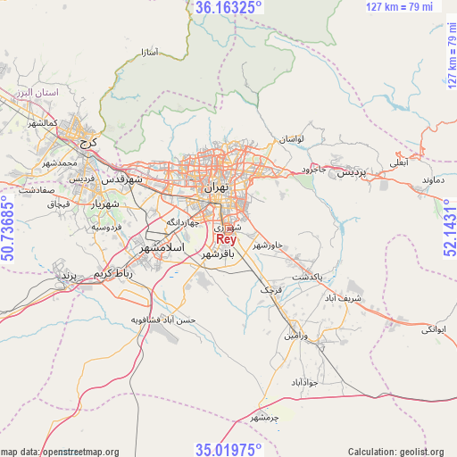
Rey GPS coordinates[2]
35° 35' 36.744" North, 51° 26' 23.892" East
| Map corner | latitude | longitude |
|---|---|---|
| Upper-left | 36.16325°, | 50.73685° |
| Center: | 35.59354°, | 51.43997° |
| Lower-right: | 35.01975°, | 52.1431° |
| Map W x H: | 127.1×127.1 km | = 79×79mi |
| max Lat: | 39.6482° ⇑35.8% North |
| Rey: | 35.59354° |
| min Lat: | ⇓64.2% South 25.2919° |
| min Long | Rey | max Long |
| 44.38416° | 51.43997° | 61.9965° |
| W 51.5%⇐ | ⇒48.5% E |
Elevation
Elevation of Rey is 1062 m = 3484 ft, and this is 13 m = 43 ft above average elevation for this country.
| Max E: |
2564 m = 8412 ft | 55.1% |
| Rey | 1062 m 3484 ft | |
| Avg. | 1049 m = 3442 ft | |
Min E: |
-24 m = -79 ft | 44.9% |
See also: Iran elevation on elevation.city.
Geographical zone
Rey is located in North temperate zone (between Tropic of Cancer and the Arctic Circle). Distance of this Northern Tropic circle is 1351.7 km =839.9 mi to South.| Distance of | km | miles | from Rey |
|---|---|---|---|
| North Pole | 6049.4 | 3758.9 | to North |
| Arctic Circle | 3443.5 | 2139.7 | to North |
| Tropic Cancer | 1351.7 | 839.9 | to South |
| Equator | 3957.6 | 2459.1 | to South |


Nearby cities:
15 places around Rey: (largest is in red/bold)
• Eqbālīyeh
33.5 km =20.8 mi,  164°
164°
• Eslāmshahr
19.1 km =11.9 mi,  256°
256°
• Pākdasht
25.5 km =15.8 mi,  120°
120°
• Pīshvā
41 km =25.5 mi,  140°
140°
• Qarchak
22.1 km =13.7 mi,  146°
146°
• Robāţ Karīm
34.5 km =21.4 mi,  249°
249°
• Shahr-e Qods
33.1 km =20.6 mi,  295°
295°
• Shahrak-e Emām Ḩasan
14.5 km =9 mi,  216°
216°
• Shahre Jadide Andisheh
39.2 km =24.4 mi,  284°
284°
• Shahrīār
35.3 km =21.9 mi, 281°
• Sharīfābād
36.3 km =22.6 mi, 120°
• Tajrīsh
23.5 km =14.6 mi,  356°
356°
• Tehran
11.3 km =7 mi,  351°
351°
• Varāmīn
35.3 km =21.9 mi, 148°
• Ţāleb ābād
13.2 km =8.2 mi, 141°
Sources, notices
• [Note1] Compared only with cities in Iran existing in our database
• [Src1] Map data: © OpenStreetMap contributors (CC-BY-SA)
• [Src2] Other city data from geonames.org with taken over terms of usage.
• [Src3] Geographical zone / Annual Mean Temperature by Robert A. Rohde @ Wikipedia
