Akureyri geodata
Akureyri (Northeast) is a seat of a first-order administrative division; located in Iceland in Atlantic/Reykjavik (GMT+0) time zone. With population of 17,693 people, there are 3 cities with bigger population in this country. Compared to other cities in Iceland, 78.3% of cities are located further ↓South; 78.3% of cities are located further ←West and 67.4% of cities have lower elevation than Akureyri. Note1


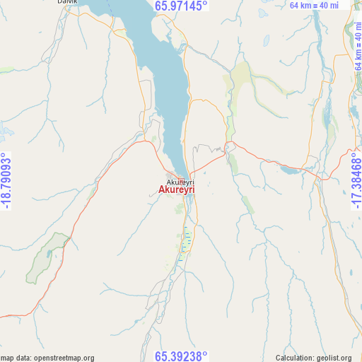
Akureyri GPS coordinates[2]
65° 41' 0.708" North, 18° 5' 16.08" West
| Map corner | latitude | longitude |
|---|---|---|
| Upper-left | 65.97145°, | -18.79093° |
| Center: | 65.68353°, | -18.0878° |
| Lower-right: | 65.39238°, | -17.38468° |
| Map W x H: | 64.4×64.4 km | = 40×40mi |
| max Lat: | 66.15917° ⇑21.7% North |
| Akureyri: | 65.68353° |
| min Lat: | ⇓78.3% South 63.44273° |
| min Long | Akureyri | max Long |
| -23.99596° | -18.0878° | -13.68368° |
| W 78.3%⇐ | ⇒21.7% E |
Elevation
Elevation of Akureyri is 27 m = 89 ft, and this is 5.7 m = 19 ft above average elevation for this country.
| Max E: |
105 m = 344 ft | 32.6% |
| Akureyri | 27 m 89 ft | |
| Avg. | 21.3 m = 70 ft | |
Min E: |
1 m = 3 ft | 67.4% |
See also: Iceland elevation on elevation.city.
Geographical zone
Akureyri is located in North temperate zone (between Tropic of Cancer and the Arctic Circle). Distance of this North polar circle is 97.9 km =60.8 mi to North.| Distance of | km | miles | from Akureyri |
|---|---|---|---|
| North Pole | 2703.7 | 1680 | to North |
| Arctic Circle | 97.9 | 60.8 | to North |
| Tropic Cancer | 4697.4 | 2918.8 | to South |
| Equator | 7303.3 | 4538.1 | to South |


Nearby cities:
15 places around Akureyri: (largest is in red/bold)
• Blönduós
100.5 km =62.4 mi,  268°
268°
• Dalvík
37.7 km =23.4 mi,  327°
327°
• Egilsstaðir
176.6 km =109.7 mi,  105°
105°
• Hella
233 km =144.8 mi,  208°
208°
• Hvammstangi
135.3 km =84.1 mi,  256°
256°
• Hvolsvöllur
237.6 km =147.6 mi, 205°
• Höfn
208.7 km =129.7 mi,  139°
139°
• Húsavík
52.4 km =32.6 mi,  40°
40°
• Laugar
33 km =20.5 mi,  82°
82°
• Reyðarfjörður
193.4 km =120.2 mi, 112°
• Sauðárkrókur
71.3 km =44.3 mi,  275°
275°
• Siglufjörður
64 km =39.8 mi,  324°
324°
• Skagaströnd
102.3 km =63.6 mi, 278°
• Vopnafjörður
149.3 km =92.8 mi,  86°
86°
• Ólafsfjörður
49.6 km =30.8 mi, 329°
Sources, notices
• [Note1] Compared only with cities in Iceland existing in our database
• [Src1] Map data: © OpenStreetMap contributors (CC-BY-SA)
• [Src2] Other city data from geonames.org with taken over terms of usage.
• [Src3] Geographical zone / Annual Mean Temperature by Robert A. Rohde @ Wikipedia
