Bettola geodata
Bettola (Emilia-Romagna) is a seat of a third-order administrative division; located in Italy in Europe/Rome (GMT+2) time zone. With population of 3,187 people, there are 2902 cities with bigger population in this country. Compared to other cities in Italy, 55.8% of cities are located further ↓South; 71.9% of cities are located further →East and 63.4% of cities have lower elevation than Bettola. Note1


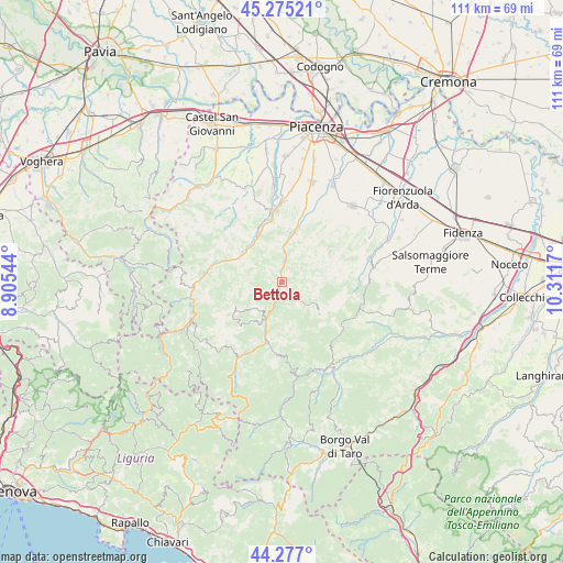
Bettola GPS coordinates[2]
44° 46' 41.736" North, 9° 36' 30.852" East
| Map corner | latitude | longitude |
|---|---|---|
| Upper-left | 45.27521°, | 8.90544° |
| Center: | 44.77826°, | 9.60857° |
| Lower-right: | 44.277°, | 10.3117° |
| Map W x H: | 111×111 km | = 69×69mi |
| max Lat: | 47.04031° ⇑44.2% North |
| Bettola: | 44.77826° |
| min Lat: | ⇓55.8% South 35.50142° |
| min Long | Bettola | max Long |
| 6.69888° | 9.60857° | 18.48682° |
| W 28.1%⇐ | ⇒71.9% E |
Elevation
Elevation of Bettola is 328 m = 1076 ft, and this is 21.3 m = 70 ft above average elevation for this country.
| Max E: |
2085 m = 6841 ft | 36.6% |
| Bettola | 328 m 1076 ft | |
| Avg. | 306.7 m = 1006 ft | |
Min E: |
-4 m = -13 ft | 63.4% |
See also: Italy elevation on elevation.city.
Geographical zone
Bettola is located in North temperate zone (between Tropic of Cancer and the Arctic Circle). Distance of this Northern Tropic circle is 2373 km =1474.5 mi to South.| Distance of | km | miles | from Bettola |
|---|---|---|---|
| North Pole | 5028.2 | 3124.4 | to North |
| Arctic Circle | 2422.3 | 1505.1 | to North |
| Tropic Cancer | 2373 | 1474.5 | to South |
| Equator | 4978.9 | 3093.7 | to South |


Nearby cities:
15 places around Bettola: (largest is in red/bold)
• Bobbio
17.7 km =11 mi,  266°
266°
• Bore
15.9 km =9.9 mi,  114°
114°
• Coli
15.7 km =9.8 mi,  256°
256°
• Farini
7.9 km =4.9 mi,  203°
203°
• Ferriere
17.4 km =10.8 mi,  210°
210°
• Gropparello
11.3 km =7 mi,  56°
56°
• Lugagnano Val d'Arda
18 km =11.2 mi,  73°
73°
• Morfasso
9.6 km =6 mi,  129°
129°
• Niviano
18.1 km =11.2 mi,  5°
5°
• Ponte dell'Olio
10.3 km =6.4 mi,  15°
15°
• Rivergaro
15.2 km =9.4 mi,  358°
358°
• San Giovanni-San Bernardino
1.6 km =1 mi,  0°
0°
• Travo
10.7 km =6.6 mi,  331°
331°
• Vernasca
17.7 km =11 mi,  82°
82°
• Vigolzone
15.8 km =9.8 mi, 17°
Sources, notices
• [Note1] Compared only with cities in Italy existing in our database
• [Src1] Map data: © OpenStreetMap contributors (CC-BY-SA)
• [Src2] Other city data from geonames.org with taken over terms of usage.
• [Src3] Geographical zone / Annual Mean Temperature by Robert A. Rohde @ Wikipedia
