Ficarolo geodata
Ficarolo (Veneto) is a seat of a third-order administrative division; located in Italy in Europe/Rome (GMT+2) time zone. With population of 2,007 people, there are 4141 cities with bigger population in this country. Compared to other cities in Italy, 59% of cities are located further ↓South; 51.4% of cities are located further →East and 94.8% of cities have higher elevation than Ficarolo. Note1


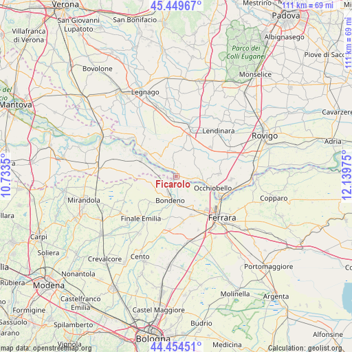
Ficarolo GPS coordinates[2]
44° 57' 15.3" North, 11° 26' 11.832" East
| Map corner | latitude | longitude |
|---|---|---|
| Upper-left | 45.44967°, | 10.7335° |
| Center: | 44.95425°, | 11.43662° |
| Lower-right: | 44.45451°, | 12.13975° |
| Map W x H: | 110.7×110.7 km | = 68.8×68.8mi |
| max Lat: | 47.04031° ⇑41% North |
| Ficarolo: | 44.95425° |
| min Lat: | ⇓59% South 35.50142° |
| min Long | Ficarolo | max Long |
| 6.69888° | 11.43662° | 18.48682° |
| W 48.6%⇐ | ⇒51.4% E |
Elevation
Elevation of Ficarolo is 9 m = 30 ft, and this is 297.7 m = 977 ft below average elevation for this country.
| Max E: |
2085 m = 6841 ft | 94.8% |
| Avg. | 306.7 m = 1006 ft | |
| Ficarolo | 9 m = 30 ft | |
Min E: |
-4 m = -13 ft | 5.2% |
See also: Italy elevation on elevation.city.
Geographical zone
Ficarolo is located in North temperate zone (between Tropic of Cancer and the Arctic Circle). Distance of this Northern Tropic circle is 2392.5 km =1486.6 mi to South.| Distance of | km | miles | from Ficarolo |
|---|---|---|---|
| North Pole | 5008.6 | 3112.2 | to North |
| Arctic Circle | 2402.7 | 1493 | to North |
| Tropic Cancer | 2392.5 | 1486.6 | to South |
| Equator | 4998.4 | 3105.9 | to South |


Nearby cities:
15 places around Ficarolo: (largest is in red/bold)
• Bagnolo di Po
8.5 km =5.3 mi,  36°
36°
• Bondeno
7.4 km =4.6 mi,  193°
193°
• Calto
7.4 km =4.6 mi,  303°
303°
• Canda
10.5 km =6.5 mi,  29°
29°
• Casaglia
10.1 km =6.3 mi,  124°
124°
• Castelguglielmo
11.2 km =7 mi, 44°
• Ceneselli
8.5 km =5.3 mi,  321°
321°
• Felonica
7.1 km =4.4 mi,  292°
292°
• Gaiba
3.6 km =2.2 mi,  105°
105°
• Pilastri
11.7 km =7.3 mi,  265°
265°
• Sabbioni-Zampine
6.7 km =4.2 mi,  91°
91°
• Salara
3.6 km =2.2 mi,  347°
347°
• Scortichino
11.3 km =7 mi,  225°
225°
• Stienta
8.6 km =5.3 mi,  100°
100°
• Trecenta
8.5 km =5.3 mi,  12°
12°
Sources, notices
• [Note1] Compared only with cities in Italy existing in our database
• [Src1] Map data: © OpenStreetMap contributors (CC-BY-SA)
• [Src2] Other city data from geonames.org with taken over terms of usage.
• [Src3] Geographical zone / Annual Mean Temperature by Robert A. Rohde @ Wikipedia
