Frontone geodata
Frontone (The Marches) is a seat of a third-order administrative division; located in Italy in Europe/Rome (GMT+2) time zone. With population of 630 people, there are 8773 cities with bigger population in this country. Compared to other cities in Italy, 59.7% of cities are located further ↑North; 65.4% of cities are located further ←West and 70.3% of cities have lower elevation than Frontone. Note1
Administrative division(s):
- Level 1: The Marches
- Level 2: Provincia di Pesaro e Urbino
- Level 3: Frontone


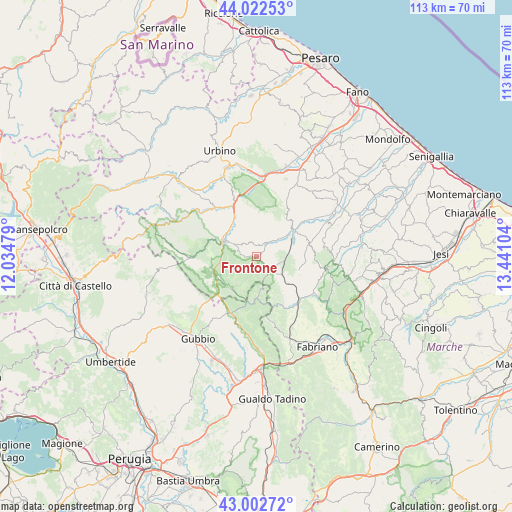
Frontone GPS coordinates[2]
43° 30' 53.208" North, 12° 44' 16.476" East
| Map corner | latitude | longitude |
|---|---|---|
| Upper-left | 44.02253°, | 12.03479° |
| Center: | 43.51478°, | 12.73791° |
| Lower-right: | 43.00272°, | 13.44104° |
| Map W x H: | 113.4×113.4 km | = 70.5×70.5mi |
| max Lat: | 47.04031° ⇑59.7% North |
| Frontone: | 43.51478° |
| min Lat: | ⇓40.3% South 35.50142° |
| min Long | Frontone | max Long |
| 6.69888° | 12.73791° | 18.48682° |
| W 65.4%⇐ | ⇒34.6% E |
Elevation
Elevation of Frontone is 397 m = 1302 ft, and this is 90.3 m = 296 ft above average elevation for this country.
| Max E: |
2085 m = 6841 ft | 29.7% |
| Frontone | 397 m 1302 ft | |
| Avg. | 306.7 m = 1006 ft | |
Min E: |
-4 m = -13 ft | 70.3% |
See also: Italy elevation on elevation.city.
Geographical zone
Frontone is located in North temperate zone (between Tropic of Cancer and the Arctic Circle). Distance of this Northern Tropic circle is 2232.5 km =1387.2 mi to South.| Distance of | km | miles | from Frontone |
|---|---|---|---|
| North Pole | 5168.7 | 3211.7 | to North |
| Arctic Circle | 2562.8 | 1592.4 | to North |
| Tropic Cancer | 2232.5 | 1387.2 | to South |
| Equator | 4838.4 | 3006.4 | to South |


Nearby cities:
15 places around Frontone: (largest is in red/bold)
• Acqualagna
13.3 km =8.3 mi,  338°
338°
• Arcevia
16.8 km =10.4 mi,  94°
94°
• Bellaria-Pole-Petriccio
14 km =8.7 mi,  321°
321°
• Cagli
7.8 km =4.8 mi,  297°
297°
• Cantiano
10.1 km =6.3 mi,  240°
240°
• Costacciaro
17.5 km =10.9 mi,  186°
186°
• Fratte Rosa
18.7 km =11.6 mi,  45°
45°
• Genga
18.5 km =11.5 mi,  120°
120°
• Pergola
9.1 km =5.7 mi,  60°
60°
• Piano di Frassineta
11.3 km =7 mi,  128°
128°
• Piobbico
20.1 km =12.5 mi,  293°
293°
• San Lorenzo in Campo
19.2 km =11.9 mi, 59°
• Sassoferrato
13.4 km =8.3 mi, 134°
• Scheggia
13.7 km =8.5 mi,  205°
205°
• Serra Sant'Abbondio
3.9 km =2.4 mi, 131°
Sources, notices
• [Note1] Compared only with cities in Italy existing in our database
• [Src1] Map data: © OpenStreetMap contributors (CC-BY-SA)
• [Src2] Other city data from geonames.org with taken over terms of usage.
• [Src3] Geographical zone / Annual Mean Temperature by Robert A. Rohde @ Wikipedia
