Coli geodata
Coli (Emilia-Romagna) is a seat of a third-order administrative division; located in Italy in Europe/Rome (GMT+2) time zone. With population of 98 people, there are 11449 cities with bigger population in this country. Compared to other cities in Italy, 55.1% of cities are located further ↓South; 74.3% of cities are located further →East and 86.6% of cities have lower elevation than Coli. Note1


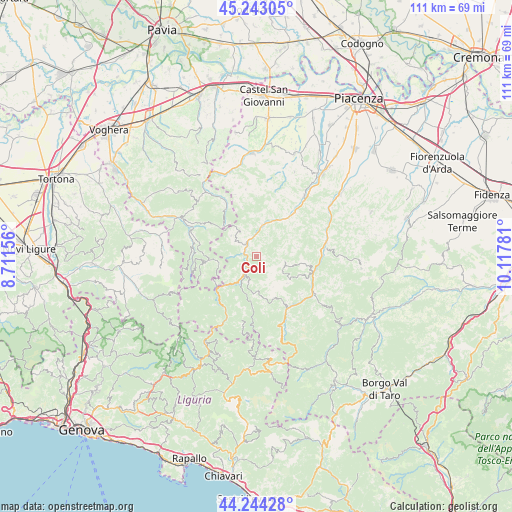
Coli GPS coordinates[2]
44° 44' 44.952" North, 9° 24' 52.848" East
| Map corner | latitude | longitude |
|---|---|---|
| Upper-left | 45.24305°, | 8.71156° |
| Center: | 44.74582°, | 9.41468° |
| Lower-right: | 44.24428°, | 10.11781° |
| Map W x H: | 111.1×111.1 km | = 69×69mi |
| max Lat: | 47.04031° ⇑44.9% North |
| Coli: | 44.74582° |
| min Lat: | ⇓55.1% South 35.50142° |
| min Long | Coli | max Long |
| 6.69888° | 9.41468° | 18.48682° |
| W 25.7%⇐ | ⇒74.3% E |
Elevation
Elevation of Coli is 644 m = 2113 ft, and this is 337.3 m = 1107 ft above average elevation for this country.
| Max E: |
2085 m = 6841 ft | 13.4% |
| Coli | 644 m 2113 ft | |
| Avg. | 306.7 m = 1006 ft | |
Min E: |
-4 m = -13 ft | 86.6% |
See also: Italy elevation on elevation.city.
Geographical zone
Coli is located in North temperate zone (between Tropic of Cancer and the Arctic Circle). Distance of this Northern Tropic circle is 2369.3 km =1472.2 mi to South.| Distance of | km | miles | from Coli |
|---|---|---|---|
| North Pole | 5031.8 | 3126.6 | to North |
| Arctic Circle | 2425.9 | 1507.4 | to North |
| Tropic Cancer | 2369.3 | 1472.2 | to South |
| Equator | 4975.3 | 3091.5 | to South |


Nearby cities:
15 places around Coli: (largest is in red/bold)
• Bettola
15.7 km =9.8 mi,  76°
76°
• Bobbio
3.5 km =2.2 mi,  316°
316°
• Cerignale
9.1 km =5.7 mi,  213°
213°
• Farini
12.7 km =7.9 mi,  106°
106°
• Ferriere
13.1 km =8.1 mi,  150°
150°
• Marsaglia
4.5 km =2.8 mi, 213°
• Menconico
12.1 km =7.5 mi,  297°
297°
• Ottone
15.1 km =9.4 mi, 205°
• Pecorara
14.7 km =9.1 mi,  350°
350°
• Pregola
10.5 km =6.5 mi,  272°
272°
• Romagnese
12.6 km =7.8 mi,  327°
327°
• San Giovanni-San Bernardino
16.2 km =10.1 mi,  71°
71°
• Santa Margherita di Staffora
14.1 km =8.8 mi,  281°
281°
• Travo
16.6 km =10.3 mi,  38°
38°
• Zerba
13.4 km =8.3 mi,  228°
228°
Sources, notices
• [Note1] Compared only with cities in Italy existing in our database
• [Src1] Map data: © OpenStreetMap contributors (CC-BY-SA)
• [Src2] Other city data from geonames.org with taken over terms of usage.
• [Src3] Geographical zone / Annual Mean Temperature by Robert A. Rohde @ Wikipedia
