Sassoferrato geodata
Sassoferrato (The Marches) is a seat of a third-order administrative division; located in Italy in Europe/Rome (GMT+2) time zone. With population of 3,806 people, there are 2503 cities with bigger population in this country. Compared to other cities in Italy, 60.4% of cities are located further ↑North; 66.7% of cities are located further ←West and 57.7% of cities have lower elevation than Sassoferrato. Note1


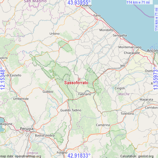
Sassoferrato GPS coordinates[2]
43° 25' 51.924" North, 12° 51' 23.76" East
| Map corner | latitude | longitude |
|---|---|---|
| Upper-left | 43.93955°, | 12.15348° |
| Center: | 43.43109°, | 12.8566° |
| Lower-right: | 42.91833°, | 13.55973° |
| Map W x H: | 113.5×113.5 km | = 70.5×70.5mi |
| max Lat: | 47.04031° ⇑60.4% North |
| Sassoferrato: | 43.43109° |
| min Lat: | ⇓39.6% South 35.50142° |
| min Long | Sassoferrato | max Long |
| 6.69888° | 12.8566° | 18.48682° |
| W 66.7%⇐ | ⇒33.3% E |
Elevation
Elevation of Sassoferrato is 284 m = 932 ft, and this is 22.7 m = 74 ft below average elevation for this country.
| Max E: |
2085 m = 6841 ft | 42.3% |
| Avg. | 306.7 m = 1006 ft | |
| Sassoferrato | 284 m = 932 ft | |
Min E: |
-4 m = -13 ft | 57.7% |
See also: Italy elevation on elevation.city.
Geographical zone
Sassoferrato is located in North temperate zone (between Tropic of Cancer and the Arctic Circle). Distance of this Northern Tropic circle is 2223.2 km =1381.4 mi to South.| Distance of | km | miles | from Sassoferrato |
|---|---|---|---|
| North Pole | 5178 | 3217.5 | to North |
| Arctic Circle | 2572.1 | 1598.2 | to North |
| Tropic Cancer | 2223.2 | 1381.4 | to South |
| Equator | 4829.1 | 3000.7 | to South |


Nearby cities:
15 places around Sassoferrato: (largest is in red/bold)
• Angeli di Mergo
16.4 km =10.2 mi,  76°
76°
• Arcevia
10.6 km =6.6 mi,  42°
42°
• Costacciaro
14.1 km =8.8 mi,  235°
235°
• Fabriano
10.9 km =6.8 mi,  159°
159°
• Frontone
13.4 km =8.3 mi,  314°
314°
• Genga
6.4 km =4 mi,  90°
90°
• Marischio
10.2 km =6.3 mi,  174°
174°
• Mergo
15.2 km =9.4 mi,  71°
71°
• Pergola
13.9 km =8.6 mi,  353°
353°
• Piano di Frassineta
2.3 km =1.4 mi,  341°
341°
• Purello
15 km =9.3 mi,  212°
212°
• Scheggia
15.7 km =9.8 mi,  258°
258°
• Serra San Quirico
13.5 km =8.4 mi, 82°
• Serra Sant'Abbondio
9.5 km =5.9 mi,  315°
315°
• Sigillo
14.5 km =9 mi,  220°
220°
Sources, notices
• [Note1] Compared only with cities in Italy existing in our database
• [Src1] Map data: © OpenStreetMap contributors (CC-BY-SA)
• [Src2] Other city data from geonames.org with taken over terms of usage.
• [Src3] Geographical zone / Annual Mean Temperature by Robert A. Rohde @ Wikipedia
