Camerino geodata
Camerino (The Marches) is a seat of a third-order administrative division; located in Italy in Europe/Rome (GMT+2) time zone. With population of 4,444 people, there are 2169 cities with bigger population in this country. Compared to other cities in Italy, 62.3% of cities are located further ↑North; 69% of cities are located further ←West and 84.2% of cities have lower elevation than Camerino. Note1


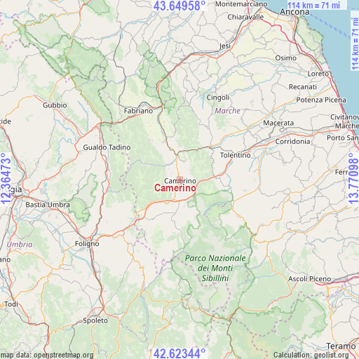
Camerino GPS coordinates[2]
43° 8' 19.176" North, 13° 4' 4.26" East
| Map corner | latitude | longitude |
|---|---|---|
| Upper-left | 43.64958°, | 12.36473° |
| Center: | 43.13866°, | 13.06785° |
| Lower-right: | 42.62344°, | 13.77098° |
| Map W x H: | 114.1×114.1 km | = 70.9×70.9mi |
| max Lat: | 47.04031° ⇑62.3% North |
| Camerino: | 43.13866° |
| min Lat: | ⇓37.7% South 35.50142° |
| min Long | Camerino | max Long |
| 6.69888° | 13.06785° | 18.48682° |
| W 69%⇐ | ⇒31% E |
Elevation
Elevation of Camerino is 596 m = 1955 ft, and this is 289.3 m = 949 ft above average elevation for this country.
| Max E: |
2085 m = 6841 ft | 15.8% |
| Camerino | 596 m 1955 ft | |
| Avg. | 306.7 m = 1006 ft | |
Min E: |
-4 m = -13 ft | 84.2% |
See also: Italy elevation on elevation.city.
Geographical zone
Camerino is located in North temperate zone (between Tropic of Cancer and the Arctic Circle). Distance of this Northern Tropic circle is 2190.7 km =1361.2 mi to South.| Distance of | km | miles | from Camerino |
|---|---|---|---|
| North Pole | 5210.5 | 3237.7 | to North |
| Arctic Circle | 2604.6 | 1618.4 | to North |
| Tropic Cancer | 2190.7 | 1361.2 | to South |
| Equator | 4796.6 | 2980.5 | to South |


Nearby cities:
15 places around Camerino: (largest is in red/bold)
• Caldarola
12.7 km =7.9 mi,  87°
87°
• Castelraimondo
7.8 km =4.8 mi,  352°
352°
• Gagliole
11.1 km =6.9 mi,  359°
359°
• Massa
12.4 km =7.7 mi,  296°
296°
• Matelica
14.1 km =8.8 mi,  339°
339°
• Muccia
6.6 km =4.1 mi,  197°
197°
• Pieve Torina
10.8 km =6.7 mi,  188°
188°
• Pievebovigliana
8.5 km =5.3 mi,  171°
171°
• Pioraco
8.7 km =5.4 mi, 302°
• San Severino Marche
13.6 km =8.5 mi,  41°
41°
• Sefro
9.7 km =6 mi,  275°
275°
• Serrapetrona
10.8 km =6.7 mi,  66°
66°
• Serravalle di Chienti
12 km =7.5 mi,  231°
231°
• Trebbio
13.3 km =8.3 mi,  148°
148°
• Valle e Castello
11.4 km =7.1 mi, 171°
Sources, notices
• [Note1] Compared only with cities in Italy existing in our database
• [Src1] Map data: © OpenStreetMap contributors (CC-BY-SA)
• [Src2] Other city data from geonames.org with taken over terms of usage.
• [Src3] Geographical zone / Annual Mean Temperature by Robert A. Rohde @ Wikipedia
