Castelraimondo geodata
Castelraimondo (The Marches) is a seat of a third-order administrative division; located in Italy in Europe/Rome (GMT+2) time zone. With population of 4,046 people, there are 2370 cities with bigger population in this country. Compared to other cities in Italy, 61.8% of cities are located further ↑North; 68.9% of cities are located further ←West and 61.2% of cities have lower elevation than Castelraimondo. Note1
Administrative division(s):
- Level 1: The Marches
- Level 2: Provincia di Macerata
- Level 3: Castelraimondo


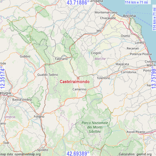
Castelraimondo GPS coordinates[2]
43° 12' 30.708" North, 13° 3' 17.496" East
| Map corner | latitude | longitude |
|---|---|---|
| Upper-left | 43.71886°, | 12.35174° |
| Center: | 43.20853°, | 13.05486° |
| Lower-right: | 42.69389°, | 13.75799° |
| Map W x H: | 114×114 km | = 70.8×70.8mi |
| max Lat: | 47.04031° ⇑61.8% North |
| Castelraimondo: | 43.20853° |
| min Lat: | ⇓38.2% South 35.50142° |
| min Long | Castelraimondo | max Long |
| 6.69888° | 13.05486° | 18.48682° |
| W 68.9%⇐ | ⇒31.1% E |
Elevation
Elevation of Castelraimondo is 308 m = 1010 ft, and this is 1.3 m = 4 ft above average elevation for this country.
| Max E: |
2085 m = 6841 ft | 38.8% |
| Castelraimondo | 308 m 1010 ft | |
| Avg. | 306.7 m = 1006 ft | |
Min E: |
-4 m = -13 ft | 61.2% |
See also: Italy elevation on elevation.city.
Geographical zone
Castelraimondo is located in North temperate zone (between Tropic of Cancer and the Arctic Circle). Distance of this Northern Tropic circle is 2198.4 km =1366 mi to South.| Distance of | km | miles | from Castelraimondo |
|---|---|---|---|
| North Pole | 5202.7 | 3232.8 | to North |
| Arctic Circle | 2596.8 | 1613.6 | to North |
| Tropic Cancer | 2198.4 | 1366 | to South |
| Equator | 4804.3 | 2985.3 | to South |


Nearby cities:
15 places around Castelraimondo: (largest is in red/bold)
• Belforte del Chienti
16 km =9.9 mi,  107°
107°
• Caldarola
15.5 km =9.6 mi,  118°
118°
• Camerino
7.8 km =4.8 mi,  172°
172°
• Cerreto d'Esi
13.2 km =8.2 mi,  335°
335°
• Cesolo
12.6 km =7.8 mi,  62°
62°
• Esanatoglia
9.8 km =6.1 mi,  299°
299°
• Gagliole
3.5 km =2.2 mi,  17°
17°
• Massa
10.3 km =6.4 mi,  257°
257°
• Matelica
6.7 km =4.2 mi,  325°
325°
• Muccia
14.1 km =8.8 mi,  183°
183°
• Pievebovigliana
16.4 km =10.2 mi, 171°
• Pioraco
7 km =4.3 mi,  243°
243°
• San Severino Marche
10.4 km =6.5 mi,  76°
76°
• Sefro
11 km =6.8 mi,  231°
231°
• Serrapetrona
11.5 km =7.1 mi, 107°
Sources, notices
• [Note1] Compared only with cities in Italy existing in our database
• [Src1] Map data: © OpenStreetMap contributors (CC-BY-SA)
• [Src2] Other city data from geonames.org with taken over terms of usage.
• [Src3] Geographical zone / Annual Mean Temperature by Robert A. Rohde @ Wikipedia
