Zerba geodata
Zerba (Emilia-Romagna) is a seat of a third-order administrative division; located in Italy in Europe/Rome (GMT+2) time zone. With population of 60 people, there are 11570 cities with bigger population in this country. Compared to other cities in Italy, 53.6% of cities are located further ↓South; 76.5% of cities are located further →East and 93.1% of cities have lower elevation than Zerba. Note1


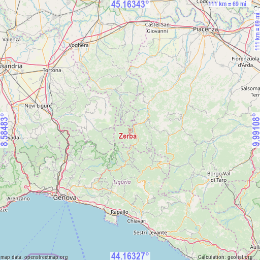
Zerba GPS coordinates[2]
44° 39' 55.836" North, 9° 17' 16.62" East
| Map corner | latitude | longitude |
|---|---|---|
| Upper-left | 45.16343°, | 8.58483° |
| Center: | 44.66551°, | 9.28795° |
| Lower-right: | 44.16327°, | 9.99108° |
| Map W x H: | 111.2×111.2 km | = 69.1×69.1mi |
| max Lat: | 47.04031° ⇑46.4% North |
| Zerba: | 44.66551° |
| min Lat: | ⇓53.6% South 35.50142° |
| min Long | Zerba | max Long |
| 6.69888° | 9.28795° | 18.48682° |
| W 23.5%⇐ | ⇒76.5% E |
Elevation
Elevation of Zerba is 806 m = 2644 ft, and this is 499.3 m = 1638 ft above average elevation for this country.
| Max E: |
2085 m = 6841 ft | 6.9% |
| Zerba | 806 m 2644 ft | |
| Avg. | 306.7 m = 1006 ft | |
Min E: |
-4 m = -13 ft | 93.1% |
See also: Italy elevation on elevation.city.
Geographical zone
Zerba is located in North temperate zone (between Tropic of Cancer and the Arctic Circle). Distance of this Northern Tropic circle is 2360.4 km =1466.7 mi to South.| Distance of | km | miles | from Zerba |
|---|---|---|---|
| North Pole | 5040.7 | 3132.1 | to North |
| Arctic Circle | 2434.8 | 1512.9 | to North |
| Tropic Cancer | 2360.4 | 1466.7 | to South |
| Equator | 4966.3 | 3085.9 | to South |


Nearby cities:
15 places around Zerba: (largest is in red/bold)
• Bobbio
13.7 km =8.5 mi,  33°
33°
• Carrega Ligure
10.3 km =6.4 mi,  239°
239°
• Cerignale
5.2 km =3.2 mi,  74°
74°
• Coli
13.4 km =8.3 mi,  48°
48°
• Fascia
10.6 km =6.6 mi,  209°
209°
• Fontanigorda
13.4 km =8.3 mi,  174°
174°
• Garadassi
14.5 km =9 mi,  312°
312°
• Gorreto
6.7 km =4.2 mi,  177°
177°
• Marsaglia
9.2 km =5.7 mi,  55°
55°
• Ottone
5.9 km =3.7 mi,  143°
143°
• Pregola
9.5 km =5.9 mi,  357°
357°
• Propata
13.8 km =8.6 mi,  215°
215°
• Rondanina
12.6 km =7.8 mi, 205°
• Rovegno
9.9 km =6.2 mi, 184°
• Santa Margherita di Staffora
12.4 km =7.7 mi,  342°
342°
Sources, notices
• [Note1] Compared only with cities in Italy existing in our database
• [Src1] Map data: © OpenStreetMap contributors (CC-BY-SA)
• [Src2] Other city data from geonames.org with taken over terms of usage.
• [Src3] Geographical zone / Annual Mean Temperature by Robert A. Rohde @ Wikipedia
