Roncoferraro geodata
Roncoferraro (Lombardy) is a seat of a third-order administrative division; located in Italy in Europe/Rome (GMT+2) time zone. With population of 2,854 people, there are 3163 cities with bigger population in this country. Compared to other cities in Italy, 63.4% of cities are located further ↓South; 58% of cities are located further →East and 89% of cities have higher elevation than Roncoferraro. Note1


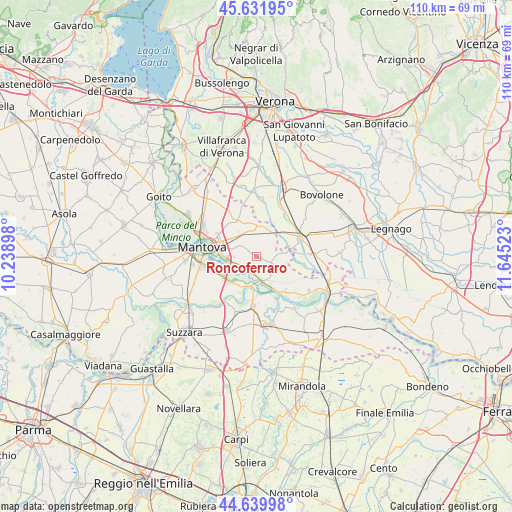
Roncoferraro GPS coordinates[2]
45° 8' 17.232" North, 10° 56' 31.56" East
| Map corner | latitude | longitude |
|---|---|---|
| Upper-left | 45.63195°, | 10.23898° |
| Center: | 45.13812°, | 10.9421° |
| Lower-right: | 44.63998°, | 11.64523° |
| Map W x H: | 110.3×110.3 km | = 68.5×68.5mi |
| max Lat: | 47.04031° ⇑36.6% North |
| Roncoferraro: | 45.13812° |
| min Lat: | ⇓63.4% South 35.50142° |
| min Long | Roncoferraro | max Long |
| 6.69888° | 10.9421° | 18.48682° |
| W 42%⇐ | ⇒58% E |
Elevation
Elevation of Roncoferraro is 20 m = 66 ft, and this is 286.7 m = 941 ft below average elevation for this country.
| Max E: |
2085 m = 6841 ft | 89% |
| Avg. | 306.7 m = 1006 ft | |
| Roncoferraro | 20 m = 66 ft | |
Min E: |
-4 m = -13 ft | 11% |
See also: Italy elevation on elevation.city.
Geographical zone
Roncoferraro is located in North temperate zone (between Tropic of Cancer and the Arctic Circle). Distance of this North polar circle is 2382.3 km =1480.3 mi to North.| Distance of | km | miles | from Roncoferraro |
|---|---|---|---|
| North Pole | 4988.2 | 3099.5 | to North |
| Arctic Circle | 2382.3 | 1480.3 | to North |
| Tropic Cancer | 2413 | 1499.4 | to South |
| Equator | 5018.9 | 3118.6 | to South |


Nearby cities:
15 places around Roncoferraro: (largest is in red/bold)
• Bagnolo San Vito
7.5 km =4.7 mi,  222°
222°
• Barbasso
3.4 km =2.1 mi,  234°
234°
• Bonferraro
7.5 km =4.7 mi,  47°
47°
• Castel d'Ario
6.1 km =3.8 mi,  24°
24°
• Castelbelforte
9.1 km =5.7 mi,  334°
334°
• Formigosa
6.2 km =3.9 mi,  256°
256°
• Gazzo
5.8 km =3.6 mi,  322°
322°
• Lunetta-Frassino
9.8 km =6.1 mi,  284°
284°
• Mottella
8.2 km =5.1 mi,  290°
290°
• Pietole
10.1 km =6.3 mi,  254°
254°
• San Biagio
8.6 km =5.3 mi,  239°
239°
• Sorgà
8.9 km =5.5 mi, 19°
• Stradella
6.6 km =4.1 mi,  305°
305°
• Sustinente
9.7 km =6 mi,  140°
140°
• Villimpenta
7 km =4.3 mi,  87°
87°
Sources, notices
• [Note1] Compared only with cities in Italy existing in our database
• [Src1] Map data: © OpenStreetMap contributors (CC-BY-SA)
• [Src2] Other city data from geonames.org with taken over terms of usage.
• [Src3] Geographical zone / Annual Mean Temperature by Robert A. Rohde @ Wikipedia
