Erbè geodata
Erbè (Veneto) is a seat of a third-order administrative division; located in Italy in Europe/Rome (GMT+2) time zone. With population of 1,540 people, there are 5037 cities with bigger population in this country. Compared to other cities in Italy, 66% of cities are located further ↓South; 57.7% of cities are located further →East and 86.7% of cities have higher elevation than Erbè. Note1


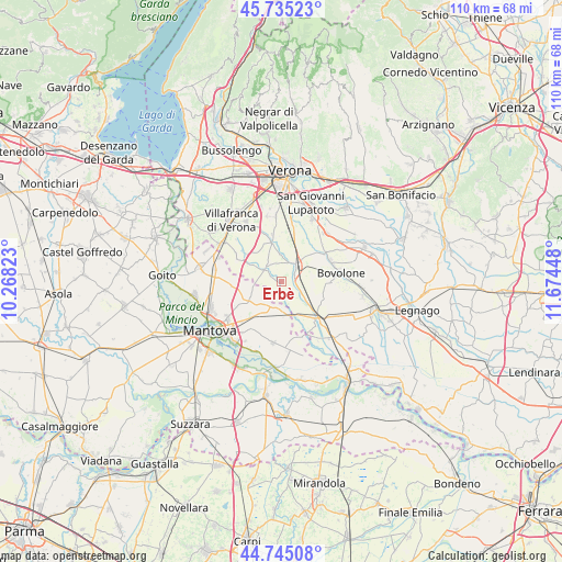
Erbè GPS coordinates[2]
45° 14' 32.316" North, 10° 58' 16.86" East
| Map corner | latitude | longitude |
|---|---|---|
| Upper-left | 45.73523°, | 10.26823° |
| Center: | 45.24231°, | 10.97135° |
| Lower-right: | 44.74508°, | 11.67448° |
| Map W x H: | 110.1×110.1 km | = 68.4×68.4mi |
| max Lat: | 47.04031° ⇑34% North |
| Erbè: | 45.24231° |
| min Lat: | ⇓66% South 35.50142° |
| min Long | Erbè | max Long |
| 6.69888° | 10.97135° | 18.48682° |
| W 42.3%⇐ | ⇒57.7% E |
Elevation
Elevation of Erbè is 26 m = 85 ft, and this is 280.7 m = 921 ft below average elevation for this country.
| Max E: |
2085 m = 6841 ft | 86.7% |
| Avg. | 306.7 m = 1006 ft | |
| Erbè | 26 m = 85 ft | |
Min E: |
-4 m = -13 ft | 13.3% |
See also: Italy elevation on elevation.city.
Geographical zone
Erbè is located in North temperate zone (between Tropic of Cancer and the Arctic Circle). Distance of this North polar circle is 2370.7 km =1473.1 mi to North.| Distance of | km | miles | from Erbè |
|---|---|---|---|
| North Pole | 4976.6 | 3092.3 | to North |
| Arctic Circle | 2370.7 | 1473.1 | to North |
| Tropic Cancer | 2424.6 | 1506.6 | to South |
| Equator | 5030.5 | 3125.8 | to South |


Nearby cities:
15 places around Erbè: (largest is in red/bold)
• Bagnolo
7.1 km =4.4 mi,  297°
297°
• Bonferraro
7.2 km =4.5 mi,  153°
153°
• Castel d'Ario
6 km =3.7 mi,  177°
177°
• Castelbelforte
7 km =4.3 mi,  241°
241°
• Gazzo
9.1 km =5.7 mi,  219°
219°
• Isola della Scala
4.2 km =2.6 mi,  43°
43°
• Nogarole Rocca
8.7 km =5.4 mi,  307°
307°
• Pellegrina
4.1 km =2.5 mi,  112°
112°
• Pradelle
9.1 km =5.7 mi, 299°
• Roncolevà
4.8 km =3 mi,  281°
281°
• Salizzole
9.7 km =6 mi,  91°
91°
• Sorgà
3.3 km =2.1 mi,  168°
168°
• Tarmassia
7.3 km =4.5 mi,  64°
64°
• Trevenzuolo
4.2 km =2.6 mi,  316°
316°
• Vigasio
8.7 km =5.4 mi,  345°
345°
Sources, notices
• [Note1] Compared only with cities in Italy existing in our database
• [Src1] Map data: © OpenStreetMap contributors (CC-BY-SA)
• [Src2] Other city data from geonames.org with taken over terms of usage.
• [Src3] Geographical zone / Annual Mean Temperature by Robert A. Rohde @ Wikipedia
