May Pen geodata
May Pen (Clarendon) is a seat of a first-order administrative division; located in Jamaica in America/Jamaica (GMT-5) time zone. With population of 44,755 people, there are 6 cities with bigger population in this country. Compared to other cities in Jamaica, 79.1% of cities are located further ↑North; 51.6% of cities are located further ←West and 57.1% of cities have higher elevation than May Pen. Note1


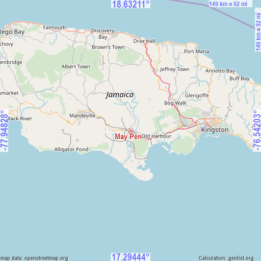
May Pen GPS coordinates[2]
17° 57' 52.344" North, 77° 14' 42.54" West
| Map corner | latitude | longitude |
|---|---|---|
| Upper-left | 18.63211°, | -77.94828° |
| Center: | 17.96454°, | -77.24515° |
| Lower-right: | 17.29444°, | -76.54203° |
| Map W x H: | 148.7×148.7 km | = 92.4×92.4mi |
| max Lat: | 18.49358° ⇑79.1% North |
| May Pen: | 17.96454° |
| min Lat: | ⇓20.9% South 17.774° |
| min Long | May Pen | max Long |
| -78.3481° | -77.24515° | -76.24864° |
| W 51.6%⇐ | ⇒48.4% E |
Elevation
Elevation of May Pen is 81 m = 266 ft, and this is 133.4 m = 438 ft below average elevation for this country.
| Max E: |
944 m = 3097 ft | 57.1% |
| Avg. | 214.4 m = 703 ft | |
| May Pen | 81 m = 266 ft | |
Min E: |
1 m = 3 ft | 42.9% |
See also: May Pen elevation on elevation.city.
Geographical zone
May Pen is located in North Torrid zone (between Equator and Tropic of Cancer). Distance of this Northern Tropic circle is 608.4 km =378 mi to North.| Distance of | km | miles | from May Pen |
|---|---|---|---|
| North Pole | 8009.6 | 4976.9 | to North |
| Arctic Circle | 5403.7 | 3357.7 | to North |
| Tropic Cancer | 608.4 | 378 | to North |
| Equator | 1997.5 | 1241.2 | to South |


Nearby cities:
15 places around May Pen: (largest is in red/bold)
• Chapelton
13.4 km =8.3 mi,  350°
350°
• Ewarton
29.6 km =18.4 mi,  34°
34°
• Hayes
9.9 km =6.2 mi,  175°
175°
• Kellits
22.1 km =13.7 mi, 353°
• Lionel Town
17.2 km =10.7 mi, 178°
• Lluidas Vale
20.7 km =12.9 mi, 29°
• Mandeville
29 km =18 mi,  287°
287°
• Mocho
12.3 km =7.6 mi,  313°
313°
• Old Harbour
14.6 km =9.1 mi,  100°
100°
• Old Harbour Bay
16.8 km =10.4 mi,  111°
111°
• Point Hill
20.1 km =12.5 mi,  46°
46°
• Porus
19.3 km =12 mi, 294°
• Race Course
14.4 km =8.9 mi,  195°
195°
• Rocky Point
21.3 km =13.2 mi, 184°
• Williamsfield
26 km =16.2 mi,  295°
295°
Sources, notices
• [Note1] Compared only with cities in Jamaica existing in our database
• [Src1] Map data: © OpenStreetMap contributors (CC-BY-SA)
• [Src2] Other city data from geonames.org with taken over terms of usage.
• [Src3] Geographical zone / Annual Mean Temperature by Robert A. Rohde @ Wikipedia
