Lionel Town geodata
Lionel Town (Clarendon) is a populated place; located in Jamaica in America/Jamaica (GMT-5) time zone. With population of 5,362 people, there are 30 cities with bigger population in this country. Compared to other cities in Jamaica, 98.9% of cities are located further ↑North; 52.7% of cities are located further ←West and 90.1% of cities have higher elevation than Lionel Town. Note1


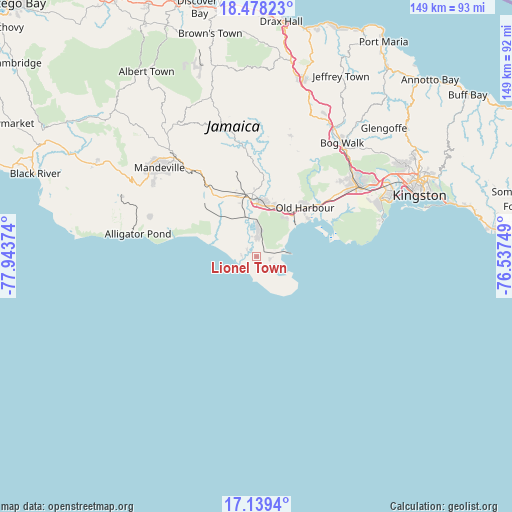
Lionel Town GPS coordinates[2]
17° 48' 36.252" North, 77° 14' 26.196" West
| Map corner | latitude | longitude |
|---|---|---|
| Upper-left | 18.47823°, | -77.94374° |
| Center: | 17.81007°, | -77.24061° |
| Lower-right: | 17.1394°, | -76.53749° |
| Map W x H: | 148.9×148.9 km | = 92.5×92.5mi |
| max Lat: | 18.49358° ⇑98.9% North |
| Lionel Town: | 17.81007° |
| min Lat: | ⇓1.1% South 17.774° |
| min Long | Lionel Town | max Long |
| -78.3481° | -77.24061° | -76.24864° |
| W 52.7%⇐ | ⇒47.3% E |
Elevation
Elevation of Lionel Town is 11 m = 36 ft, and this is 203.4 m = 667 ft below average elevation for this country.
| Max E: |
944 m = 3097 ft | 90.1% |
| Avg. | 214.4 m = 703 ft | |
| Lionel Town | 11 m = 36 ft | |
Min E: |
1 m = 3 ft | 9.9% |
See also: Jamaica elevation on elevation.city.
Geographical zone
Lionel Town is located in North Torrid zone (between Equator and Tropic of Cancer). Distance of this Northern Tropic circle is 625.6 km =388.7 mi to North.| Distance of | km | miles | from Lionel Town |
|---|---|---|---|
| North Pole | 8026.8 | 4987.6 | to North |
| Arctic Circle | 5420.9 | 3368.4 | to North |
| Tropic Cancer | 625.6 | 388.7 | to North |
| Equator | 1980.3 | 1230.5 | to South |


Nearby cities:
15 places around Lionel Town: (largest is in red/bold)
• Alligator Pond
35.2 km =21.9 mi,  280°
280°
• Bull Savanna
38 km =23.6 mi, 282°
• Chapelton
30.5 km =19 mi,  354°
354°
• Hayes
7.3 km =4.5 mi,  2°
2°
• Lluidas Vale
36.4 km =22.6 mi,  15°
15°
• May Pen
17.2 km =10.7 mi,  358°
358°
• Mocho
27.3 km =17 mi,  339°
339°
• Old Harbour
20.2 km =12.6 mi,  43°
43°
• Old Harbour Bay
18.8 km =11.7 mi,  54°
54°
• Point Hill
34.1 km =21.2 mi, 24°
• Porus
30.9 km =19.2 mi,  324°
324°
• Race Course
5.5 km =3.4 mi,  307°
307°
• Rocky Point
4.6 km =2.9 mi,  208°
208°
• Spanish Town
36.1 km =22.4 mi,  56°
56°
• Williamsfield
37.2 km =23.1 mi, 320°
Sources, notices
• [Note1] Compared only with cities in Jamaica existing in our database
• [Src1] Map data: © OpenStreetMap contributors (CC-BY-SA)
• [Src2] Other city data from geonames.org with taken over terms of usage.
• [Src3] Geographical zone / Annual Mean Temperature by Robert A. Rohde @ Wikipedia
