Hayes geodata
Hayes (Clarendon) is a populated place; located in Jamaica in America/Jamaica (GMT-5) time zone. With population of 9,701 people, there are 16 cities with bigger population in this country. Compared to other cities in Jamaica, 94.5% of cities are located further ↑North; 53.8% of cities are located further ←West and 70.3% of cities have higher elevation than Hayes. Note1


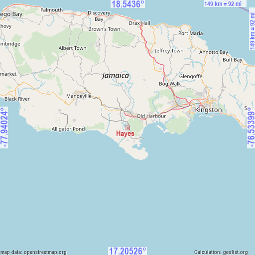
Hayes GPS coordinates[2]
17° 52' 32.484" North, 77° 14' 13.596" West
| Map corner | latitude | longitude |
|---|---|---|
| Upper-left | 18.5436°, | -77.94024° |
| Center: | 17.87569°, | -77.23711° |
| Lower-right: | 17.20526°, | -76.53399° |
| Map W x H: | 148.8×148.8 km | = 92.5×92.5mi |
| max Lat: | 18.49358° ⇑94.5% North |
| Hayes: | 17.87569° |
| min Lat: | ⇓5.5% South 17.774° |
| min Long | Hayes | max Long |
| -78.3481° | -77.23711° | -76.24864° |
| W 53.8%⇐ | ⇒46.2% E |
Elevation
Elevation of Hayes is 38 m = 125 ft, and this is 176.4 m = 579 ft below average elevation for this country.
| Max E: |
944 m = 3097 ft | 70.3% |
| Avg. | 214.4 m = 703 ft | |
| Hayes | 38 m = 125 ft | |
Min E: |
1 m = 3 ft | 29.7% |
See also: Jamaica elevation on elevation.city.
Geographical zone
Hayes is located in North Torrid zone (between Equator and Tropic of Cancer). Distance of this Northern Tropic circle is 618.3 km =384.2 mi to North.| Distance of | km | miles | from Hayes |
|---|---|---|---|
| North Pole | 8019.5 | 4983.1 | to North |
| Arctic Circle | 5413.6 | 3363.9 | to North |
| Tropic Cancer | 618.3 | 384.2 | to North |
| Equator | 1987.6 | 1235 | to South |


Nearby cities:
15 places around Hayes: (largest is in red/bold)
• Chapelton
23.3 km =14.5 mi,  352°
352°
• Kellits
32 km =19.9 mi, 353°
• Lionel Town
7.3 km =4.5 mi,  182°
182°
• Lluidas Vale
29.4 km =18.3 mi,  18°
18°
• Mandeville
34 km =21.1 mi,  302°
302°
• May Pen
9.9 km =6.2 mi,  355°
355°
• Mocho
20.7 km =12.9 mi,  331°
331°
• Old Harbour
15.4 km =9.6 mi,  61°
61°
• Old Harbour Bay
15.3 km =9.5 mi,  75°
75°
• Point Hill
27.5 km =17.1 mi,  29°
29°
• Porus
25.6 km =15.9 mi,  313°
313°
• Race Course
6.2 km =3.9 mi,  230°
230°
• Rocky Point
11.6 km =7.2 mi,  192°
192°
• Spanish Town
32.2 km =20 mi,  66°
66°
• Williamsfield
32.3 km =20.1 mi, 311°
Sources, notices
• [Note1] Compared only with cities in Jamaica existing in our database
• [Src1] Map data: © OpenStreetMap contributors (CC-BY-SA)
• [Src2] Other city data from geonames.org with taken over terms of usage.
• [Src3] Geographical zone / Annual Mean Temperature by Robert A. Rohde @ Wikipedia
