‘Ajlūn geodata
‘Ajlūn (Ajlun) is a seat of a first-order administrative division; located in Jordan in Asia/Amman (GMT+3) time zone. With population of 125,557 people, there are 5 cities with bigger population in this country. Compared to other cities in Jordan, 66.7% of cities are located further ↓South; 62.3% of cities are located further →East and 55.1% of cities have lower elevation than ‘Ajlūn. Note1


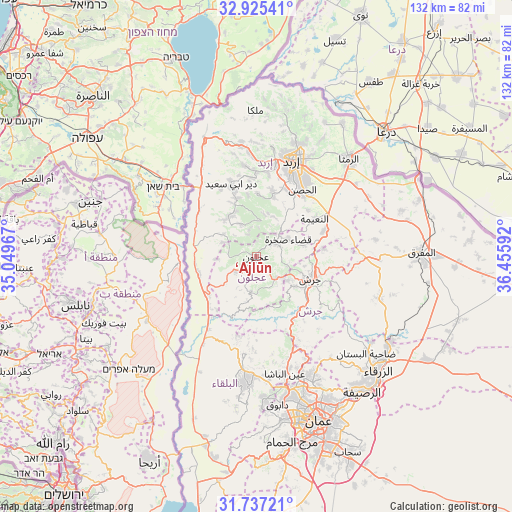
‘Ajlūn GPS coordinates[2]
32° 19' 59.736" North, 35° 45' 10.044" East
| Map corner | latitude | longitude |
|---|---|---|
| Upper-left | 32.92541°, | 35.04967° |
| Center: | 32.33326°, | 35.75279° |
| Lower-right: | 31.73721°, | 36.45592° |
| Map W x H: | 132.1×132.1 km | = 82.1×82.1mi |
| max Lat: | 33.31405° ⇑33.3% North |
| ‘Ajlūn: | 32.33326° |
| min Lat: | ⇓66.7% South 29.40842° |
| min Long | ‘Ajlūn | max Long |
| 34.97918° | 35.75279° | 38.70342° |
| W 37.7%⇐ | ⇒62.3% E |
Elevation
Elevation of ‘Ajlūn is 769 m = 2523 ft, and this is 83.3 m = 273 ft above average elevation for this country.
| Max E: |
1440 m = 4724 ft | 44.9% |
| ‘Ajlūn | 769 m 2523 ft | |
| Avg. | 685.7 m = 2250 ft | |
Min E: |
-366 m = -1201 ft | 55.1% |
See also: ‘Ajlūn elevation on elevation.city.
Geographical zone
‘Ajlūn is located in North temperate zone (between Tropic of Cancer and the Arctic Circle). Distance of this Northern Tropic circle is 989.2 km =614.7 mi to South.| Distance of | km | miles | from ‘Ajlūn |
|---|---|---|---|
| North Pole | 6411.9 | 3984.2 | to North |
| Arctic Circle | 3806.1 | 2365 | to North |
| Tropic Cancer | 989.2 | 614.7 | to South |
| Equator | 3595.1 | 2233.9 | to South |


Nearby cities:
15 places around ‘Ajlūn: (largest is in red/bold)
• Al Kittah
10.4 km =6.5 mi,  127°
127°
• Bayt Īdis
12.7 km =7.9 mi,  335°
335°
• Burmā
13 km =8.1 mi,  166°
166°
• Jarash
15 km =9.3 mi,  112°
112°
• Judita
9.3 km =5.8 mi,  333°
333°
• Kafr Abīl
12.6 km =7.8 mi,  318°
318°
• Kufrinjah
6.2 km =3.9 mi,  230°
230°
• Raymūn
9.1 km =5.7 mi, 128°
• Sakib
7.6 km =4.7 mi,  135°
135°
• Sūf
8.2 km =5.1 mi, 105°
• Şakhrah
9.4 km =5.8 mi,  63°
63°
• Ḩalāwah
10.3 km =6.4 mi,  303°
303°
• ‘Anjarah
3 km =1.9 mi, 173°
• ‘Ayn Jannah
1 km =0.6 mi,  81°
81°
• ‘Irjān
7 km =4.3 mi,  345°
345°
Sources, notices
• [Note1] Compared only with cities in Jordan existing in our database
• [Src1] Map data: © OpenStreetMap contributors (CC-BY-SA)
• [Src2] Other city data from geonames.org with taken over terms of usage.
• [Src3] Geographical zone / Annual Mean Temperature by Robert A. Rohde @ Wikipedia
