‘Ayn Jannah geodata
‘Ayn Jannah (Ajlun) is a populated place; located in Jordan in Asia/Amman (GMT+3) time zone. With population of 9,586 people, there are 37 cities with bigger population in this country. Compared to other cities in Jordan, 67.4% of cities are located further ↓South; 59.4% of cities are located further →East and 71.7% of cities have lower elevation than ‘Ayn Jannah. Note1


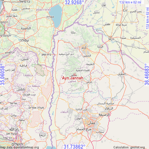
‘Ayn Jannah GPS coordinates[2]
32° 20' 4.776" North, 35° 45' 49.32" East
| Map corner | latitude | longitude |
|---|---|---|
| Upper-left | 32.9268°, | 35.06058° |
| Center: | 32.33466°, | 35.7637° |
| Lower-right: | 31.73862°, | 36.46683° |
| Map W x H: | 132.1×132.1 km | = 82.1×82.1mi |
| max Lat: | 33.31405° ⇑32.6% North |
| ‘Ayn Jannah: | 32.33466° |
| min Lat: | ⇓67.4% South 29.40842° |
| min Long | ‘Ayn Jannah | max Long |
| 34.97918° | 35.7637° | 38.70342° |
| W 40.6%⇐ | ⇒59.4% E |
Elevation
Elevation of ‘Ayn Jannah is 871 m = 2858 ft, and this is 185.3 m = 608 ft above average elevation for this country.
| Max E: |
1440 m = 4724 ft | 28.3% |
| ‘Ayn Jannah | 871 m 2858 ft | |
| Avg. | 685.7 m = 2250 ft | |
Min E: |
-366 m = -1201 ft | 71.7% |
See also: Jordan elevation on elevation.city.
Geographical zone
‘Ayn Jannah is located in North temperate zone (between Tropic of Cancer and the Arctic Circle). Distance of this Northern Tropic circle is 989.4 km =614.8 mi to South.| Distance of | km | miles | from ‘Ayn Jannah |
|---|---|---|---|
| North Pole | 6411.8 | 3984.1 | to North |
| Arctic Circle | 3805.9 | 2364.9 | to North |
| Tropic Cancer | 989.4 | 614.8 | to South |
| Equator | 3595.3 | 2234 | to South |


Nearby cities:
15 places around ‘Ayn Jannah: (largest is in red/bold)
• Al Kittah
9.7 km =6 mi,  131°
131°
• Bayt Īdis
13 km =8.1 mi,  331°
331°
• Burmā
13 km =8.1 mi,  171°
171°
• Jarash
14.1 km =8.8 mi,  115°
115°
• Judita
9.7 km =6 mi, 327°
• Kafr Abīl
13.2 km =8.2 mi,  314°
314°
• Kufrinjah
7.1 km =4.4 mi,  234°
234°
• Raymūn
8.4 km =5.2 mi, 134°
• Sakib
7 km =4.3 mi,  142°
142°
• Sūf
7.3 km =4.5 mi,  108°
108°
• Şakhrah
8.4 km =5.2 mi,  61°
61°
• Ḩalāwah
11.1 km =6.9 mi,  299°
299°
• ‘Ajlūn
1 km =0.6 mi,  261°
261°
• ‘Anjarah
3.2 km =2 mi,  192°
192°
• ‘Irjān
7.2 km =4.5 mi,  336°
336°
Sources, notices
• [Note1] Compared only with cities in Jordan existing in our database
• [Src1] Map data: © OpenStreetMap contributors (CC-BY-SA)
• [Src2] Other city data from geonames.org with taken over terms of usage.
• [Src3] Geographical zone / Annual Mean Temperature by Robert A. Rohde @ Wikipedia
