Ar Ramthā geodata
Ar Ramthā (Irbid) is a seat of a second-order administrative division; located in Jordan in Asia/Amman (GMT+3) time zone. With population of 74,901 people, there are 10 cities with bigger population in this country. Compared to other cities in Jordan, 87.7% of cities are located further ↓South; 80.4% of cities are located further ←West and 77.5% of cities have higher elevation than Ar Ramthā. Note1


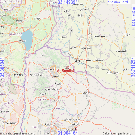
Ar Ramthā GPS coordinates[2]
32° 33' 31.428" North, 36° 0' 29.376" East
| Map corner | latitude | longitude |
|---|---|---|
| Upper-left | 33.14939°, | 35.30504° |
| Center: | 32.55873°, | 36.00816° |
| Lower-right: | 31.96416°, | 36.71129° |
| Map W x H: | 131.8×131.8 km | = 81.9×81.9mi |
| max Lat: | 33.31405° ⇑12.3% North |
| Ar Ramthā: | 32.55873° |
| min Lat: | ⇓87.7% South 29.40842° |
| min Long | Ar Ramthā | max Long |
| 34.97918° | 36.00816° | 38.70342° |
| W 80.4%⇐ | ⇒19.6% E |
Elevation
Elevation of Ar Ramthā is 536 m = 1759 ft, and this is 149.7 m = 491 ft below average elevation for this country.
| Max E: |
1440 m = 4724 ft | 77.5% |
| Avg. | 685.7 m = 2250 ft | |
| Ar Ramthā | 536 m = 1759 ft | |
Min E: |
-366 m = -1201 ft | 22.5% |
See also: Ar Ramthā elevation on elevation.city.
Geographical zone
Ar Ramthā is located in North temperate zone (between Tropic of Cancer and the Arctic Circle). Distance of this Northern Tropic circle is 1014.3 km =630.3 mi to South.| Distance of | km | miles | from Ar Ramthā |
|---|---|---|---|
| North Pole | 6386.9 | 3968.6 | to North |
| Arctic Circle | 3781 | 2349.4 | to North |
| Tropic Cancer | 1014.3 | 630.3 | to South |
| Equator | 3620.2 | 2249.5 | to South |


Nearby cities:
15 places around Ar Ramthā: (largest is in red/bold)
• Al Ḩamrā’
18.9 km =11.7 mi,  134°
134°
• Al Ḩişn
14.3 km =8.9 mi,  234°
234°
• Ash Shajarah
11.3 km =7 mi,  326°
326°
• Aydūn
15.3 km =9.5 mi,  247°
247°
• Aţ Ţurrah
9.2 km =5.7 mi,  348°
348°
• Balīlā
19.8 km =12.3 mi,  199°
199°
• Bayt Yāfā
21.2 km =13.2 mi,  259°
259°
• Dayr Yūsuf
21.4 km =13.3 mi, 248°
• Irbid
14.8 km =9.2 mi,  268°
268°
• Kharjā
15.9 km =9.9 mi,  314°
314°
• Kitim
17 km =10.6 mi,  217°
217°
• Sammā ar Rawsān
19.2 km =11.9 mi,  297°
297°
• Sāl
9.1 km =5.7 mi,  277°
277°
• Ḩakamā
12.3 km =7.6 mi,  288°
288°
• Ḩawshā
14.7 km =9.1 mi,  144°
144°
Sources, notices
• [Note1] Compared only with cities in Jordan existing in our database
• [Src1] Map data: © OpenStreetMap contributors (CC-BY-SA)
• [Src2] Other city data from geonames.org with taken over terms of usage.
• [Src3] Geographical zone / Annual Mean Temperature by Robert A. Rohde @ Wikipedia
