Al Ḩamrā’ geodata
Al Ḩamrā’ (Mafraq) is a populated place; located in Jordan in Asia/Amman (GMT+3) time zone. With population of 6,211 people, there are 52 cities with bigger population in this country. Compared to other cities in Jordan, 76.8% of cities are located further ↓South; 88.4% of cities are located further ←West and 54.3% of cities have higher elevation than Al Ḩamrā’. Note1


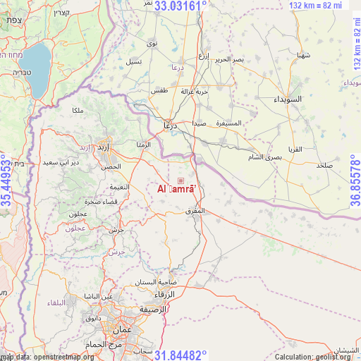
Al Ḩamrā’ GPS coordinates[2]
32° 26' 24.612" North, 36° 9' 9.54" East
| Map corner | latitude | longitude |
|---|---|---|
| Upper-left | 33.03161°, | 35.44953° |
| Center: | 32.44017°, | 36.15265° |
| Lower-right: | 31.84482°, | 36.85578° |
| Map W x H: | 132×132 km | = 82×82mi |
| max Lat: | 33.31405° ⇑23.2% North |
| Al Ḩamrā’: | 32.44017° |
| min Lat: | ⇓76.8% South 29.40842° |
| min Long | Al Ḩamrā’ | max Long |
| 34.97918° | 36.15265° | 38.70342° |
| W 88.4%⇐ | ⇒11.6% E |
Elevation
Elevation of Al Ḩamrā’ is 697 m = 2287 ft, and this is 11.3 m = 37 ft above average elevation for this country.
| Max E: |
1440 m = 4724 ft | 54.3% |
| Al Ḩamrā’ | 697 m 2287 ft | |
| Avg. | 685.7 m = 2250 ft | |
Min E: |
-366 m = -1201 ft | 45.7% |
See also: Jordan elevation on elevation.city.
Geographical zone
Al Ḩamrā’ is located in North temperate zone (between Tropic of Cancer and the Arctic Circle). Distance of this Northern Tropic circle is 1001.1 km =622.1 mi to South.| Distance of | km | miles | from Al Ḩamrā’ |
|---|---|---|---|
| North Pole | 6400.1 | 3976.8 | to North |
| Arctic Circle | 3794.2 | 2357.6 | to North |
| Tropic Cancer | 1001.1 | 622.1 | to South |
| Equator | 3607 | 2241.3 | to South |


Nearby cities:
15 places around Al Ḩamrā’: (largest is in red/bold)
• Al Ḩişn
25.7 km =16 mi,  281°
281°
• Ar Ramthā
18.9 km =11.7 mi,  314°
314°
• Aţ Ţurrah
27 km =16.8 mi,  325°
325°
• Balīlā
20.8 km =12.9 mi,  254°
254°
• Bal‘amā
23.4 km =14.5 mi,  194°
194°
• Kitim
24 km =14.9 mi,  269°
269°
• Mafraq
12 km =7.5 mi,  154°
154°
• Manshīyat Banī Ḩasan
10.3 km =6.4 mi,  221°
221°
• Muthallath Jāmi‘at Āl al Bayt
12.9 km =8 mi,  144°
144°
• Qafqafā
22.5 km =14 mi,  243°
243°
• Rehab
14.2 km =8.8 mi,  204°
204°
• Samā as Sirḩān
9.1 km =5.7 mi,  69°
69°
• Sāl
26.7 km =16.6 mi,  302°
302°
• Umm al Jimāl
23.7 km =14.7 mi,  121°
121°
• Ḩawshā
5.2 km =3.2 mi, 283°
Sources, notices
• [Note1] Compared only with cities in Jordan existing in our database
• [Src1] Map data: © OpenStreetMap contributors (CC-BY-SA)
• [Src2] Other city data from geonames.org with taken over terms of usage.
• [Src3] Geographical zone / Annual Mean Temperature by Robert A. Rohde @ Wikipedia
