Ḩawshā geodata
Ḩawshā (Mafraq) is a seat of a third-order administrative division; located in Jordan in Asia/Amman (GMT+3) time zone. In our database, there are 84 cities with bigger population. Compared to other cities in Jordan, 78.3% of cities are located further ↓South; 86.2% of cities are located further ←West and 50% of cities have lower elevation than Ḩawshā. Note1


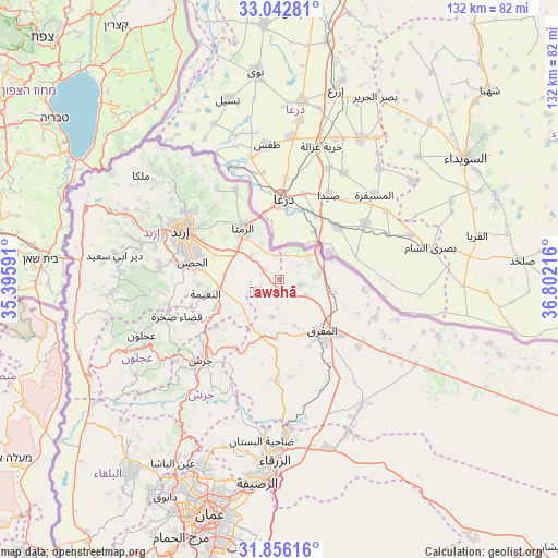
Ḩawshā GPS coordinates[2]
32° 27' 5.184" North, 36° 5' 56.508" East
| Map corner | latitude | longitude |
|---|---|---|
| Upper-left | 33.04281°, | 35.39591° |
| Center: | 32.45144°, | 36.09903° |
| Lower-right: | 31.85616°, | 36.80216° |
| Map W x H: | 131.9×131.9 km | = 82×82mi |
| max Lat: | 33.31405° ⇑21.7% North |
| Ḩawshā: | 32.45144° |
| min Lat: | ⇓78.3% South 29.40842° |
| min Long | Ḩawshā | max Long |
| 34.97918° | 36.09903° | 38.70342° |
| W 86.2%⇐ | ⇒13.8% E |
Elevation
Elevation of Ḩawshā is 735 m = 2411 ft, and this is 49.3 m = 162 ft above average elevation for this country.
| Max E: |
1440 m = 4724 ft | 50% |
| Ḩawshā | 735 m 2411 ft | |
| Avg. | 685.7 m = 2250 ft | |
Min E: |
-366 m = -1201 ft | 50% |
See also: Jordan elevation on elevation.city.
Geographical zone
Ḩawshā is located in North temperate zone (between Tropic of Cancer and the Arctic Circle). Distance of this Northern Tropic circle is 1002.3 km =622.8 mi to South.| Distance of | km | miles | from Ḩawshā |
|---|---|---|---|
| North Pole | 6398.8 | 3976 | to North |
| Arctic Circle | 3792.9 | 2356.8 | to North |
| Tropic Cancer | 1002.3 | 622.8 | to South |
| Equator | 3608.3 | 2242.1 | to South |


Nearby cities:
15 places around Ḩawshā: (largest is in red/bold)
• Al Ḩamrā’
5.2 km =3.2 mi,  103°
103°
• Al Ḩişn
20.5 km =12.7 mi,  280°
280°
• Ar Ramthā
14.7 km =9.1 mi,  324°
324°
• Aydūn
23.4 km =14.5 mi, 284°
• Aţ Ţurrah
23.3 km =14.5 mi,  333°
333°
• Balīlā
16.5 km =10.3 mi,  246°
246°
• Bal‘amā
23.9 km =14.9 mi,  182°
182°
• Kitim
19 km =11.8 mi,  265°
265°
• Mafraq
15.8 km =9.8 mi,  139°
139°
• Manshīyat Banī Ḩasan
9.2 km =5.7 mi,  191°
191°
• Muthallath Jāmi‘at Āl al Bayt
17.2 km =10.7 mi,  132°
132°
• Qafqafā
18.9 km =11.7 mi,  232°
232°
• Rehab
14.3 km =8.9 mi, 183°
• Samā as Sirḩān
13.7 km =8.5 mi,  81°
81°
• Sāl
21.9 km =13.6 mi,  306°
306°
Sources, notices
• [Note1] Compared only with cities in Jordan existing in our database
• [Src1] Map data: © OpenStreetMap contributors (CC-BY-SA)
• [Src2] Other city data from geonames.org with taken over terms of usage.
• [Src3] Geographical zone / Annual Mean Temperature by Robert A. Rohde @ Wikipedia
