Hōjō geodata
Hōjō (Ehime) is a populated place; located in Japan in Asia/Tokyo (GMT+9) time zone. With population of 27,992 people, there are 564 cities with bigger population in this country. Compared to other cities in Japan, 80.5% of cities are located further ↑North; 80.2% of cities are located further →East and 81.8% of cities have higher elevation than Hōjō. Note1


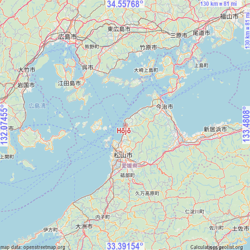
Hōjō GPS coordinates[2]
33° 58' 35.796" North, 132° 46' 39.612" East
| Map corner | latitude | longitude |
|---|---|---|
| Upper-left | 34.55768°, | 132.07455° |
| Center: | 33.97661°, | 132.77767° |
| Lower-right: | 33.39154°, | 133.4808° |
| Map W x H: | 129.7×129.7 km | = 80.6×80.6mi |
| max Lat: | 45.40944° ⇑80.5% North |
| Hōjō: | 33.97661° |
| min Lat: | ⇓19.5% South 24.34478° |
| min Long | Hōjō | max Long |
| 123° | 132.77767° | 145.575° |
| W 19.8%⇐ | ⇒80.2% E |
Elevation
Elevation of Hōjō is 7 m = 23 ft, and this is 77.6 m = 255 ft below average elevation for this country.
| Max E: |
1086 m = 3563 ft | 81.8% |
| Avg. | 84.6 m = 278 ft | |
| Hōjō | 7 m = 23 ft | |
Min E: |
-2 m = -7 ft | 18.2% |
See also: Japan elevation on elevation.city.
Geographical zone
Hōjō is located in North temperate zone (between Tropic of Cancer and the Arctic Circle). Distance of this Northern Tropic circle is 1171.9 km =728.2 mi to South.| Distance of | km | miles | from Hōjō |
|---|---|---|---|
| North Pole | 6229.2 | 3870.6 | to North |
| Arctic Circle | 3623.3 | 2251.4 | to North |
| Tropic Cancer | 1171.9 | 728.2 | to South |
| Equator | 3777.8 | 2347.4 | to South |


Nearby cities:
15 places around Hōjō: (largest is in red/bold)
• Etajima
40 km =24.9 mi,  316°
316°
• Higashihiroshima
48.2 km =30 mi,  355°
355°
• Imabari-shi
23 km =14.3 mi,  63°
63°
• Innoshima
50.6 km =31.4 mi,  47°
47°
• Iwakuni
55.4 km =34.4 mi,  291°
291°
• Iyo
26 km =16.2 mi,  195°
195°
• Kure
34.4 km =21.4 mi,  325°
325°
• Masaki-chō
21.9 km =13.6 mi, 196°
• Matsuyama
15.3 km =9.5 mi,  184°
184°
• Mihara
54.8 km =34.1 mi,  30°
30°
• Miyajima
55.2 km =34.3 mi,  310°
310°
• Niihama
48.7 km =30.3 mi,  92°
92°
• Saijō
38 km =23.6 mi,  100°
100°
• Takehara
42.2 km =26.2 mi,  17°
17°
• Tōon
22.8 km =14.2 mi,  152°
152°
Sources, notices
• [Note1] Compared only with cities in Japan existing in our database
• [Src1] Map data: © OpenStreetMap contributors (CC-BY-SA)
• [Src2] Other city data from geonames.org with taken over terms of usage.
• [Src3] Geographical zone / Annual Mean Temperature by Robert A. Rohde @ Wikipedia
