Kure geodata
Kure (Hiroshima) is a seat of a second-order administrative division; located in Japan in Asia/Tokyo (GMT+9) time zone. With population of 196,624 people, there are 103 cities with bigger population in this country. Compared to other cities in Japan, 77% of cities are located further ↑North; 81.1% of cities are located further →East and 76.2% of cities have lower elevation than Kure. Note1


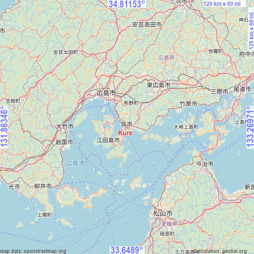
Kure GPS coordinates[2]
34° 13' 55.992" North, 132° 33' 59.688" East
| Map corner | latitude | longitude |
|---|---|---|
| Upper-left | 34.81153°, | 131.86346° |
| Center: | 34.23222°, | 132.56658° |
| Lower-right: | 33.6489°, | 133.26971° |
| Map W x H: | 129.3×129.3 km | = 80.3×80.3mi |
| max Lat: | 45.40944° ⇑77% North |
| Kure: | 34.23222° |
| min Lat: | ⇓23% South 24.34478° |
| min Long | Kure | max Long |
| 123° | 132.56658° | 145.575° |
| W 18.9%⇐ | ⇒81.1% E |
Elevation
Elevation of Kure is 102 m = 335 ft, and this is 17.4 m = 57 ft above average elevation for this country.
| Max E: |
1086 m = 3563 ft | 23.8% |
| Kure | 102 m 335 ft | |
| Avg. | 84.6 m = 278 ft | |
Min E: |
-2 m = -7 ft | 76.2% |
See also: Kure elevation on elevation.city.
Geographical zone
Kure is located in North temperate zone (between Tropic of Cancer and the Arctic Circle). Distance of this Northern Tropic circle is 1200.3 km =745.8 mi to South.| Distance of | km | miles | from Kure |
|---|---|---|---|
| North Pole | 6200.8 | 3853 | to North |
| Arctic Circle | 3594.9 | 2233.8 | to North |
| Tropic Cancer | 1200.3 | 745.8 | to South |
| Equator | 3806.3 | 2365.1 | to South |


Nearby cities:
15 places around Kure: (largest is in red/bold)
• Aki-takata
50.3 km =31.3 mi,  12°
12°
• Etajima
8 km =5 mi,  275°
275°
• Hatsukaichi
25.1 km =15.6 mi,  301°
301°
• Higashihiroshima
25.1 km =15.6 mi,  38°
38°
• Hiroshima
21.5 km =13.4 mi,  330°
330°
• Hōjō
34.4 km =21.4 mi,  145°
145°
• Imabari-shi
43.8 km =27.2 mi,  114°
114°
• Iwakuni
32.8 km =20.4 mi,  256°
256°
• Matsuyama
47.4 km =29.5 mi,  157°
157°
• Mihara
51 km =31.7 mi,  68°
68°
• Miyajima
23.7 km =14.7 mi,  288°
288°
• Takehara
34.3 km =21.3 mi, 69°
• Yanai
50.9 km =31.6 mi,  234°
234°
• Ōno-hara
28.1 km =17.5 mi, 281°
• Ōtake
31.9 km =19.8 mi,  265°
265°
Sources, notices
• [Note1] Compared only with cities in Japan existing in our database
• [Src1] Map data: © OpenStreetMap contributors (CC-BY-SA)
• [Src2] Other city data from geonames.org with taken over terms of usage.
• [Src3] Geographical zone / Annual Mean Temperature by Robert A. Rohde @ Wikipedia
