Sasayama geodata
Sasayama (Hyōgo) is a seat of a second-order administrative division; located in Japan in Asia/Tokyo (GMT+9) time zone. With population of 47,204 people, there are 391 cities with bigger population in this country. Compared to other cities in Japan, 57% of cities are located further ↑North; 69.4% of cities are located further →East and 88.3% of cities have lower elevation than Sasayama. Note1


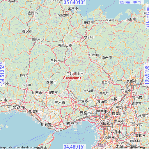
Sasayama GPS coordinates[2]
35° 4' 0.012" North, 135° 13' 0.012" East
| Map corner | latitude | longitude |
|---|---|---|
| Upper-left | 35.64013°, | 134.51355° |
| Center: | 35.06667°, | 135.21667° |
| Lower-right: | 34.48915°, | 135.9198° |
| Map W x H: | 128×128 km | = 79.5×79.5mi |
| max Lat: | 45.40944° ⇑57% North |
| Sasayama: | 35.06667° |
| min Lat: | ⇓43% South 24.34478° |
| min Long | Sasayama | max Long |
| 123° | 135.21667° | 145.575° |
| W 30.6%⇐ | ⇒69.4% E |
Elevation
Elevation of Sasayama is 202 m = 663 ft, and this is 117.4 m = 385 ft above average elevation for this country.
| Max E: |
1086 m = 3563 ft | 11.7% |
| Sasayama | 202 m 663 ft | |
| Avg. | 84.6 m = 278 ft | |
Min E: |
-2 m = -7 ft | 88.3% |
See also: Sasayama elevation on elevation.city.
Geographical zone
Sasayama is located in North temperate zone (between Tropic of Cancer and the Arctic Circle). Distance of this Northern Tropic circle is 1293.1 km =803.5 mi to South.| Distance of | km | miles | from Sasayama |
|---|---|---|---|
| North Pole | 6108 | 3795.3 | to North |
| Arctic Circle | 3502.1 | 2176.1 | to North |
| Tropic Cancer | 1293.1 | 803.5 | to South |
| Equator | 3899 | 2422.7 | to South |


Nearby cities:
15 places around Sasayama: (largest is in red/bold)
• Ayabe
26.1 km =16.2 mi,  6°
6°
• Fukuchiyama
27.5 km =17.1 mi,  340°
340°
• Ikeda
33.4 km =20.8 mi,  144°
144°
• Kameoka
34.2 km =21.3 mi,  102°
102°
• Katō
23.5 km =14.6 mi,  227°
227°
• Kawanishi
26.5 km =16.5 mi, 141°
• Kawanishi
33.2 km =20.6 mi,  146°
146°
• Mino
35.3 km =21.9 mi, 139°
• Nantan
25.5 km =15.8 mi,  79°
79°
• Nishiwaki
23.9 km =14.9 mi,  247°
247°
• Sanda
13.3 km =8.3 mi,  181°
181°
• Sandachō
20.3 km =12.6 mi, 177°
• Takarazuka
32.4 km =20.1 mi,  156°
156°
• Tanba
19.2 km =11.9 mi,  302°
302°
• Yashiro
28.2 km =17.5 mi, 233°
Sources, notices
• [Note1] Compared only with cities in Japan existing in our database
• [Src1] Map data: © OpenStreetMap contributors (CC-BY-SA)
• [Src2] Other city data from geonames.org with taken over terms of usage.
• [Src3] Geographical zone / Annual Mean Temperature by Robert A. Rohde @ Wikipedia
