Hyūga geodata
Hyūga (Miyazaki) is a seat of a second-order administrative division; located in Japan in Asia/Tokyo (GMT+9) time zone. In our database, there are 767 cities with bigger population. Compared to other cities in Japan, 93.9% of cities are located further ↑North; 83.7% of cities are located further →East and 93.5% of cities have higher elevation than Hyūga. Note1


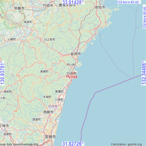
Hyūga GPS coordinates[2]
32° 25' 21.792" North, 131° 38' 27.348" East
| Map corner | latitude | longitude |
|---|---|---|
| Upper-left | 33.01428°, | 130.93781° |
| Center: | 32.42272°, | 131.64093° |
| Lower-right: | 31.82726°, | 132.34406° |
| Map W x H: | 132×132 km | = 82×82mi |
| max Lat: | 45.40944° ⇑93.9% North |
| Hyūga: | 32.42272° |
| min Lat: | ⇓6.1% South 24.34478° |
| min Long | Hyūga | max Long |
| 123° | 131.64093° | 145.575° |
| W 16.3%⇐ | ⇒83.7% E |
Elevation
Elevation of Hyūga is 4 m = 13 ft, and this is 80.6 m = 264 ft below average elevation for this country.
| Max E: |
1086 m = 3563 ft | 93.5% |
| Avg. | 84.6 m = 278 ft | |
| Hyūga | 4 m = 13 ft | |
Min E: |
-2 m = -7 ft | 6.5% |
See also: Japan elevation on elevation.city.
Geographical zone
Hyūga is located in North temperate zone (between Tropic of Cancer and the Arctic Circle). Distance of this Northern Tropic circle is 999.1 km =620.8 mi to South.| Distance of | km | miles | from Hyūga |
|---|---|---|---|
| North Pole | 6402 | 3978 | to North |
| Arctic Circle | 3796.1 | 2358.8 | to North |
| Tropic Cancer | 999.1 | 620.8 | to South |
| Equator | 3605.1 | 2240.1 | to South |


Nearby cities:
15 places around Hyūga: (largest is in red/bold)
• Aso
77.6 km =48.2 mi,  317°
317°
• Bungo-ōno
61.9 km =38.5 mi,  350°
350°
• Ebino
85.7 km =53.3 mi,  240°
240°
• Hitoyoshi
86.8 km =53.9 mi,  254°
254°
• Kobayashi
78.8 km =49 mi,  231°
231°
• Miyazaki
60.1 km =37.3 mi,  200°
200°
• Nobeoka
18 km =11.2 mi,  7°
7°
• Saiki
63.4 km =39.4 mi,  22°
22°
• Saito
44.2 km =27.5 mi,  210°
210°
• Takanabe
34.8 km =21.6 mi, 202°
• Takedamachi
64.5 km =40.1 mi,  339°
339°
• Taketa
64.9 km =40.3 mi, 336°
• Tsukumiura
75.6 km =47 mi, 16°
• Tsuma
42.4 km =26.3 mi, 212°
• Usuki
79.4 km =49.3 mi, 11°
Sources, notices
• [Note1] Compared only with cities in Japan existing in our database
• [Src1] Map data: © OpenStreetMap contributors (CC-BY-SA)
• [Src2] Other city data from geonames.org with taken over terms of usage.
• [Src3] Geographical zone / Annual Mean Temperature by Robert A. Rohde @ Wikipedia
