Nichinan geodata
Nichinan (Miyazaki) is a seat of a second-order administrative division; located in Japan in Asia/Tokyo (GMT+9) time zone. With population of 44,243 people, there are 414 cities with bigger population in this country. Compared to other cities in Japan, 96.4% of cities are located further ↑North; 85.3% of cities are located further →East and 50.9% of cities have lower elevation than Nichinan. Note1


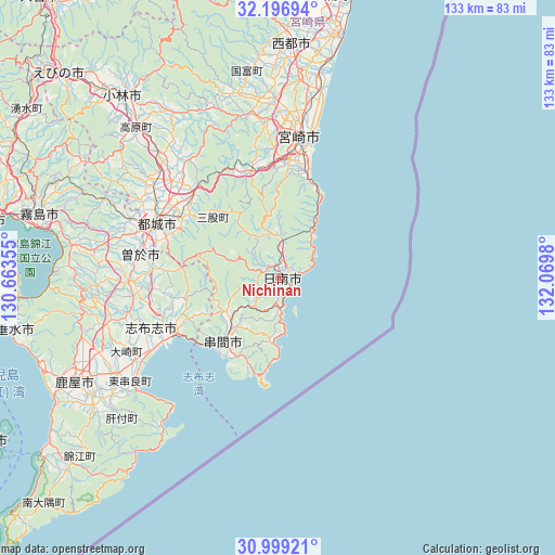
Nichinan GPS coordinates[2]
31° 36' 0" North, 131° 22' 0.012" East
| Map corner | latitude | longitude |
|---|---|---|
| Upper-left | 32.19694°, | 130.66355° |
| Center: | 31.6°, | 131.36667° |
| Lower-right: | 30.99921°, | 132.0698° |
| Map W x H: | 133.2×133.2 km | = 82.8×82.8mi |
| max Lat: | 45.40944° ⇑96.4% North |
| Nichinan: | 31.6° |
| min Lat: | ⇓3.6% South 24.34478° |
| min Long | Nichinan | max Long |
| 123° | 131.36667° | 145.575° |
| W 14.7%⇐ | ⇒85.3% E |
Elevation
Elevation of Nichinan is 29 m = 95 ft, and this is 55.6 m = 182 ft below average elevation for this country.
| Max E: |
1086 m = 3563 ft | 49.1% |
| Avg. | 84.6 m = 278 ft | |
| Nichinan | 29 m = 95 ft | |
Min E: |
-2 m = -7 ft | 50.9% |
See also: Nichinan elevation on elevation.city.
Geographical zone
Nichinan is located in North temperate zone (between Tropic of Cancer and the Arctic Circle). Distance of this Northern Tropic circle is 907.7 km =564 mi to South.| Distance of | km | miles | from Nichinan |
|---|---|---|---|
| North Pole | 6493.5 | 4034.9 | to North |
| Arctic Circle | 3887.6 | 2415.6 | to North |
| Tropic Cancer | 907.7 | 564 | to South |
| Equator | 3513.6 | 2183.2 | to South |


Nearby cities:
15 places around Nichinan: (largest is in red/bold)
• Hamanoichi
61.3 km =38.1 mi,  282°
282°
• Kanoya
54.6 km =33.9 mi,  243°
243°
• Kirishima
59.2 km =36.8 mi,  285°
285°
• Kobayashi
55.9 km =34.7 mi,  319°
319°
• Kokubu-matsuki
58.7 km =36.5 mi, 284°
• Kushima
17.3 km =10.7 mi,  223°
223°
• Miyakonojō
32 km =19.9 mi,  297°
297°
• Miyazaki
35.5 km =22.1 mi,  7°
7°
• Saito
53.7 km =33.4 mi,  3°
3°
• Shibushi
28.7 km =17.8 mi, 241°
• Soo
36 km =22.4 mi, 278°
• Sueyoshichō-ninokata
33.6 km =20.9 mi, 279°
• Takanabe
60.6 km =37.7 mi, 11°
• Tarumizu
64.5 km =40.1 mi,  258°
258°
• Tsuma
55.7 km =34.6 mi, 3°
Sources, notices
• [Note1] Compared only with cities in Japan existing in our database
• [Src1] Map data: © OpenStreetMap contributors (CC-BY-SA)
• [Src2] Other city data from geonames.org with taken over terms of usage.
• [Src3] Geographical zone / Annual Mean Temperature by Robert A. Rohde @ Wikipedia
