Sueyoshichō-ninokata geodata
Sueyoshichō-ninokata (Kagoshima) is a populated place; located in Japan in Asia/Tokyo (GMT+9) time zone. With population of 19,986 people, there are 696 cities with bigger population in this country. Compared to other cities in Japan, 96.1% of cities are located further ↑North; 87% of cities are located further →East and 86.7% of cities have lower elevation than Sueyoshichō-ninokata. Note1


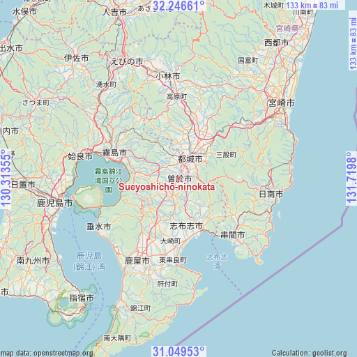
Sueyoshichō-ninokata GPS coordinates[2]
31° 39' 0" North, 131° 1' 0.012" East
| Map corner | latitude | longitude |
|---|---|---|
| Upper-left | 32.24661°, | 130.31355° |
| Center: | 31.65°, | 131.01667° |
| Lower-right: | 31.04953°, | 131.7198° |
| Map W x H: | 133.1×133.1 km | = 82.7×82.7mi |
| max Lat: | 45.40944° ⇑96.1% North |
| Sueyoshichō-ninokata: | 31.65° |
| min Lat: | ⇓3.9% South 24.34478° |
| min Long | Sueyoshichō-ni | max Long |
| 123° | 131.01667° | 145.575° |
| W 13%⇐ | ⇒87% E |
Elevation
Elevation of Sueyoshichō-ninokata is 188 m = 617 ft, and this is 103.4 m = 339 ft above average elevation for this country.
| Max E: |
1086 m = 3563 ft | 13.3% |
| Sueyoshichō-ninokata | 188 m 617 ft | |
| Avg. | 84.6 m = 278 ft | |
Min E: |
-2 m = -7 ft | 86.7% |
See also: Japan elevation on elevation.city.
Geographical zone
Sueyoshichō-ninokata is located in North temperate zone (between Tropic of Cancer and the Arctic Circle). Distance of this Northern Tropic circle is 913.2 km =567.4 mi to South.| Distance of | km | miles | from Sueyoshichō-ninokata |
|---|---|---|---|
| North Pole | 6487.9 | 4031.4 | to North |
| Arctic Circle | 3882 | 2412.2 | to North |
| Tropic Cancer | 913.2 | 567.4 | to South |
| Equator | 3519.2 | 2186.7 | to South |


Nearby cities:
15 places around Sueyoshichō-ninokata: (largest is in red/bold)
• Aira
42.5 km =26.4 mi,  288°
288°
• Ebino
47.1 km =29.3 mi,  339°
339°
• Hamanoichi
27.8 km =17.3 mi, 285°
• Kagoshima
45.2 km =28.1 mi,  258°
258°
• Kajiki
34.4 km =21.4 mi, 285°
• Kanoya
33.6 km =20.9 mi,  208°
208°
• Kirishima
26 km =16.2 mi, 292°
• Kobayashi
37.2 km =23.1 mi,  355°
355°
• Kokubu-matsuki
25.4 km =15.8 mi, 291°
• Kushima
28.1 km =17.5 mi,  130°
130°
• Miyakonojō
10.4 km =6.5 mi,  27°
27°
• Nichinan
33.6 km =20.9 mi,  99°
99°
• Shibushi
20.9 km =13 mi,  157°
157°
• Soo
2.5 km =1.6 mi, 260°
• Tarumizu
35.3 km =21.9 mi,  238°
238°
Sources, notices
• [Note1] Compared only with cities in Japan existing in our database
• [Src1] Map data: © OpenStreetMap contributors (CC-BY-SA)
• [Src2] Other city data from geonames.org with taken over terms of usage.
• [Src3] Geographical zone / Annual Mean Temperature by Robert A. Rohde @ Wikipedia
