Hamanoichi geodata
Hamanoichi (Kagoshima) is a populated place; located in Japan in Asia/Tokyo (GMT+9) time zone. With population of 39,475 people, there are 458 cities with bigger population in this country. Compared to other cities in Japan, 96.1% of cities are located further ↑North; 89.1% of cities are located further →East and 99.8% of cities have higher elevation than Hamanoichi. Note1


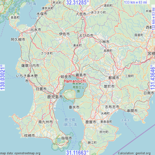
Hamanoichi GPS coordinates[2]
31° 43' 0.012" North, 130° 43' 59.988" East
| Map corner | latitude | longitude |
|---|---|---|
| Upper-left | 32.31285°, | 130.03021° |
| Center: | 31.71667°, | 130.73333° |
| Lower-right: | 31.11663°, | 131.43646° |
| Map W x H: | 133×133 km | = 82.6×82.6mi |
| max Lat: | 45.40944° ⇑96.1% North |
| Hamanoichi: | 31.71667° |
| min Lat: | ⇓3.9% South 24.34478° |
| min Long | Hamanoichi | max Long |
| 123° | 130.73333° | 145.575° |
| W 10.9%⇐ | ⇒89.1% E |
Elevation
Elevation of Hamanoichi is -1 m = -3 ft, and this is 85.6 m = 281 ft below average elevation for this country.
| Max E: |
1086 m = 3563 ft | 99.8% |
| Avg. | 84.6 m = 278 ft | |
| Hamanoichi | -1 m = -3 ft | |
Min E: |
-2 m = -7 ft | 0.2% |
See also: Japan elevation on elevation.city.
Geographical zone
Hamanoichi is located in North temperate zone (between Tropic of Cancer and the Arctic Circle). Distance of this Northern Tropic circle is 920.6 km =572 mi to South.| Distance of | km | miles | from Hamanoichi |
|---|---|---|---|
| North Pole | 6480.5 | 4026.8 | to North |
| Arctic Circle | 3874.6 | 2407.6 | to North |
| Tropic Cancer | 920.6 | 572 | to South |
| Equator | 3526.6 | 2191.3 | to South |


Nearby cities:
15 places around Hamanoichi: (largest is in red/bold)
• Aira
14.8 km =9.2 mi,  295°
295°
• Ebino
38.3 km =23.8 mi,  15°
15°
• Hioki
39.2 km =24.4 mi,  247°
247°
• Ijūin
33.4 km =20.8 mi, 250°
• Kagoshima
24.1 km =15 mi,  226°
226°
• Kajiki
6.6 km =4.1 mi,  286°
286°
• Kanoya
38.7 km =24 mi,  163°
163°
• Kirishima
3.9 km =2.4 mi,  46°
46°
• Kobayashi
37.9 km =23.5 mi,  38°
38°
• Kokubu-matsuki
3.7 km =2.3 mi,  59°
59°
• Miyakonojō
31.6 km =19.6 mi,  86°
86°
• Soo
25.6 km =15.9 mi,  107°
107°
• Sueyoshichō-ninokata
27.8 km =17.3 mi, 105°
• Tarumizu
26.1 km =16.2 mi,  186°
186°
• Yotsueda
33.1 km =20.6 mi,  0°
0°
Sources, notices
• [Note1] Compared only with cities in Japan existing in our database
• [Src1] Map data: © OpenStreetMap contributors (CC-BY-SA)
• [Src2] Other city data from geonames.org with taken over terms of usage.
• [Src3] Geographical zone / Annual Mean Temperature by Robert A. Rohde @ Wikipedia
