Miyazaki geodata
Miyazaki is a seat of a first-order administrative division; located in Japan in Asia/Tokyo (GMT+9) time zone. With population of 311,203 people, there are 62 cities with bigger population in this country. Compared to other cities in Japan, 95.2% of cities are located further ↑North; 84.7% of cities are located further →East and 71.1% of cities have higher elevation than Miyazaki. Note1


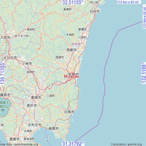
Miyazaki GPS coordinates[2]
31° 55' 0.012" North, 131° 25' 0.012" East
| Map corner | latitude | longitude |
|---|---|---|
| Upper-left | 32.51155°, | 130.71355° |
| Center: | 31.91667°, | 131.41667° |
| Lower-right: | 31.31792°, | 132.1198° |
| Map W x H: | 132.7×132.7 km | = 82.5×82.5mi |
| max Lat: | 45.40944° ⇑95.2% North |
| Miyazaki: | 31.91667° |
| min Lat: | ⇓4.8% South 24.34478° |
| min Long | Miyazaki | max Long |
| 123° | 131.41667° | 145.575° |
| W 15.3%⇐ | ⇒84.7% E |
Elevation
Elevation of Miyazaki is 11 m = 36 ft, and this is 73.6 m = 241 ft below average elevation for this country.
| Max E: |
1086 m = 3563 ft | 71.1% |
| Avg. | 84.6 m = 278 ft | |
| Miyazaki | 11 m = 36 ft | |
Min E: |
-2 m = -7 ft | 28.9% |
See also: Miyazaki elevation on elevation.city.
Geographical zone
Miyazaki is located in North temperate zone (between Tropic of Cancer and the Arctic Circle). Distance of this Northern Tropic circle is 942.9 km =585.9 mi to South.| Distance of | km | miles | from Miyazaki |
|---|---|---|---|
| North Pole | 6458.3 | 4013 | to North |
| Arctic Circle | 3852.4 | 2393.8 | to North |
| Tropic Cancer | 942.9 | 585.9 | to South |
| Equator | 3548.8 | 2205.1 | to South |


Nearby cities:
15 places around Miyazaki: (largest is in red/bold)
• Ebino
55.9 km =34.7 mi,  285°
285°
• Hyūga
60.1 km =37.3 mi,  20°
20°
• Kirishima
64.8 km =40.3 mi,  252°
252°
• Kobayashi
41.6 km =25.8 mi,  280°
280°
• Kokubu-matsuki
64.7 km =40.2 mi, 251°
• Kushima
50.6 km =31.4 mi,  199°
199°
• Miyakonojō
38.8 km =24.1 mi,  238°
238°
• Nichinan
35.5 km =22.1 mi,  187°
187°
• Saito
18.5 km =11.5 mi,  354°
354°
• Shibushi
57.4 km =35.7 mi,  211°
211°
• Soo
50.2 km =31.2 mi,  233°
233°
• Sueyoshichō-ninokata
48 km =29.8 mi, 231°
• Takanabe
25.3 km =15.7 mi, 18°
• Tsuma
20.4 km =12.7 mi,  355°
355°
• Yotsueda
65.2 km =40.5 mi, 279°
Sources, notices
• [Note1] Compared only with cities in Japan existing in our database
• [Src1] Map data: © OpenStreetMap contributors (CC-BY-SA)
• [Src2] Other city data from geonames.org with taken over terms of usage.
• [Src3] Geographical zone / Annual Mean Temperature by Robert A. Rohde @ Wikipedia
