Kirishima geodata
Kirishima (Kagoshima) is a seat of a second-order administrative division; located in Japan in Asia/Tokyo (GMT+9) time zone. In our database, there are 767 cities with bigger population. Compared to other cities in Japan, 95.5% of cities are located further ↑North; 88.6% of cities are located further →East and 73.6% of cities have higher elevation than Kirishima. Note1


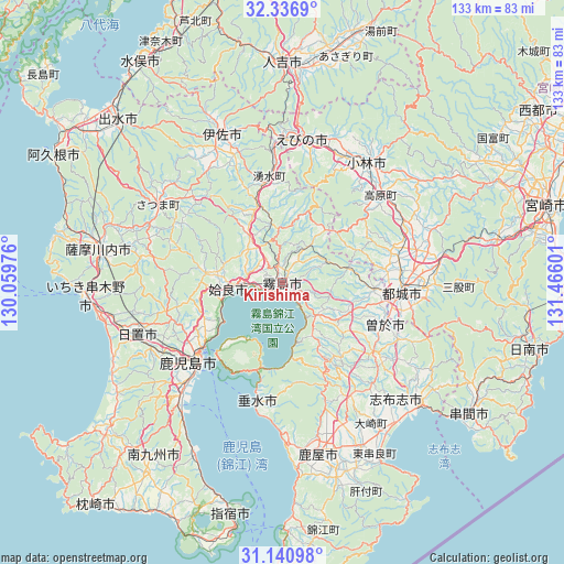
Kirishima GPS coordinates[2]
31° 44' 27.132" North, 130° 45' 46.368" East
| Map corner | latitude | longitude |
|---|---|---|
| Upper-left | 32.3369°, | 130.05976° |
| Center: | 31.74087°, | 130.76288° |
| Lower-right: | 31.14098°, | 131.46601° |
| Map W x H: | 133×133 km | = 82.6×82.6mi |
| max Lat: | 45.40944° ⇑95.5% North |
| Kirishima: | 31.74087° |
| min Lat: | ⇓4.5% South 24.34478° |
| min Long | Kirishima | max Long |
| 123° | 130.76288° | 145.575° |
| W 11.4%⇐ | ⇒88.6% E |
Elevation
Elevation of Kirishima is 10 m = 33 ft, and this is 74.6 m = 245 ft below average elevation for this country.
| Max E: |
1086 m = 3563 ft | 73.6% |
| Avg. | 84.6 m = 278 ft | |
| Kirishima | 10 m = 33 ft | |
Min E: |
-2 m = -7 ft | 26.4% |
See also: Japan elevation on elevation.city.
Geographical zone
Kirishima is located in North temperate zone (between Tropic of Cancer and the Arctic Circle). Distance of this Northern Tropic circle is 923.3 km =573.7 mi to South.| Distance of | km | miles | from Kirishima |
|---|---|---|---|
| North Pole | 6477.8 | 4025.1 | to North |
| Arctic Circle | 3871.9 | 2405.9 | to North |
| Tropic Cancer | 923.3 | 573.7 | to South |
| Equator | 3529.3 | 2193 | to South |


Nearby cities:
15 places around Kirishima: (largest is in red/bold)
• Aira
16.6 km =10.3 mi,  282°
282°
• Ebino
35 km =21.7 mi,  12°
12°
• Hamanoichi
3.9 km =2.4 mi,  226°
226°
• Ijūin
37 km =23 mi,  248°
248°
• Isa
39 km =24.2 mi,  338°
338°
• Kagoshima
27.9 km =17.3 mi, 226°
• Kajiki
9.1 km =5.7 mi,  264°
264°
• Kobayashi
34.1 km =21.2 mi,  37°
37°
• Kokubu-matsuki
0.9 km =0.6 mi,  156°
156°
• Miyakonojō
28.7 km =17.8 mi,  91°
91°
• Soo
24 km =14.9 mi,  115°
115°
• Sueyoshichō-ninokata
26 km =16.2 mi,  112°
112°
• Tarumizu
29.2 km =18.1 mi,  191°
191°
• Yotsueda
30.5 km =19 mi,  355°
355°
• Ōkuchi-shinohara
38.6 km =24 mi, 340°
Sources, notices
• [Note1] Compared only with cities in Japan existing in our database
• [Src1] Map data: © OpenStreetMap contributors (CC-BY-SA)
• [Src2] Other city data from geonames.org with taken over terms of usage.
• [Src3] Geographical zone / Annual Mean Temperature by Robert A. Rohde @ Wikipedia
