Nagasaki geodata
Nagasaki is a seat of a first-order administrative division; located in Japan in Asia/Tokyo (GMT+9) time zone. With population of 410,204 people, there are 35 cities with bigger population in this country. Compared to other cities in Japan, 92.8% of cities are located further ↑North; 97.3% of cities are located further →East and 65.3% of cities have higher elevation than Nagasaki. Note1


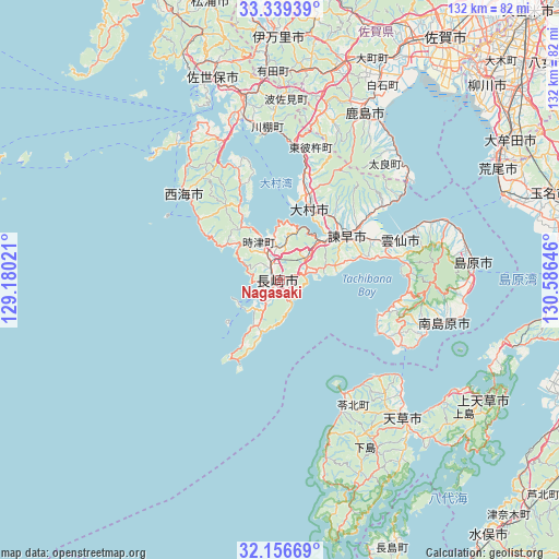
Nagasaki GPS coordinates[2]
32° 45' 0" North, 129° 52' 59.988" East
| Map corner | latitude | longitude |
|---|---|---|
| Upper-left | 33.33939°, | 129.18021° |
| Center: | 32.75°, | 129.88333° |
| Lower-right: | 32.15669°, | 130.58646° |
| Map W x H: | 131.5×131.5 km | = 81.7×81.7mi |
| max Lat: | 45.40944° ⇑92.8% North |
| Nagasaki: | 32.75° |
| min Lat: | ⇓7.2% South 24.34478° |
| min Long | Nagasaki | max Long |
| 123° | 129.88333° | 145.575° |
| W 2.7%⇐ | ⇒97.3% E |
Elevation
Elevation of Nagasaki is 15 m = 49 ft, and this is 69.6 m = 228 ft below average elevation for this country.
| Max E: |
1086 m = 3563 ft | 65.3% |
| Avg. | 84.6 m = 278 ft | |
| Nagasaki | 15 m = 49 ft | |
Min E: |
-2 m = -7 ft | 34.7% |
See also: Nagasaki elevation on elevation.city.
Geographical zone
Nagasaki is located in North temperate zone (between Tropic of Cancer and the Arctic Circle). Distance of this Northern Tropic circle is 1035.5 km =643.4 mi to South.| Distance of | km | miles | from Nagasaki |
|---|---|---|---|
| North Pole | 6365.6 | 3955.4 | to North |
| Arctic Circle | 3759.7 | 2336.2 | to North |
| Tropic Cancer | 1035.5 | 643.4 | to South |
| Equator | 3641.5 | 2262.7 | to South |


Nearby cities:
15 places around Nagasaki: (largest is in red/bold)
• Amakusa
43.5 km =27 mi,  138°
138°
• Hondomachi-hondo
41.8 km =26 mi, 140°
• Isahaya
18 km =11.2 mi,  55°
55°
• Kashima
44.1 km =27.4 mi,  26°
26°
• Minamishimabara
36.9 km =22.9 mi,  103°
103°
• Obita
7.4 km =4.6 mi,  0°
0°
• Saikai
32.2 km =20 mi,  323°
323°
• Sasebo
48.8 km =30.3 mi,  342°
342°
• Shimabara
45.3 km =28.1 mi,  85°
85°
• Takeo
50.6 km =31.4 mi,  13°
13°
• Togitsu
9.8 km =6.1 mi, 341°
• Unzen
34.2 km =21.3 mi, 86°
• Ureshino
45.8 km =28.5 mi,  20°
20°
• Ureshinomachi-shimojuku
41.9 km =26 mi, 15°
• Ōmura
20.2 km =12.6 mi, 19°
Sources, notices
• [Note1] Compared only with cities in Japan existing in our database
• [Src1] Map data: © OpenStreetMap contributors (CC-BY-SA)
• [Src2] Other city data from geonames.org with taken over terms of usage.
• [Src3] Geographical zone / Annual Mean Temperature by Robert A. Rohde @ Wikipedia
