Amakusa geodata
Amakusa (Kumamoto) is a seat of a second-order administrative division; located in Japan in Asia/Tokyo (GMT+9) time zone. In our database, there are 767 cities with bigger population. Compared to other cities in Japan, 93.9% of cities are located further ↑North; 96% of cities are located further →East and 86% of cities have higher elevation than Amakusa. Note1


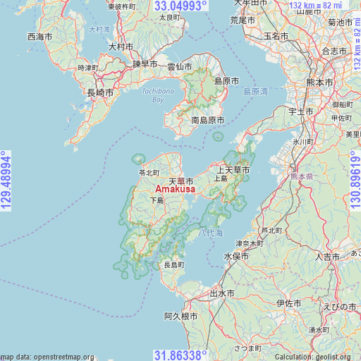
Amakusa GPS coordinates[2]
32° 27' 30.996" North, 130° 11' 35.016" East
| Map corner | latitude | longitude |
|---|---|---|
| Upper-left | 33.04993°, | 129.48994° |
| Center: | 32.45861°, | 130.19306° |
| Lower-right: | 31.86338°, | 130.89619° |
| Map W x H: | 131.9×131.9 km | = 82×82mi |
| max Lat: | 45.40944° ⇑93.9% North |
| Amakusa: | 32.45861° |
| min Lat: | ⇓6.1% South 24.34478° |
| min Long | Amakusa | max Long |
| 123° | 130.19306° | 145.575° |
| W 4%⇐ | ⇒96% E |
Elevation
Elevation of Amakusa is 6 m = 20 ft, and this is 78.6 m = 258 ft below average elevation for this country.
| Max E: |
1086 m = 3563 ft | 86% |
| Avg. | 84.6 m = 278 ft | |
| Amakusa | 6 m = 20 ft | |
Min E: |
-2 m = -7 ft | 14% |
See also: Japan elevation on elevation.city.
Geographical zone
Amakusa is located in North temperate zone (between Tropic of Cancer and the Arctic Circle). Distance of this Northern Tropic circle is 1003.1 km =623.3 mi to South.| Distance of | km | miles | from Amakusa |
|---|---|---|---|
| North Pole | 6398 | 3975.5 | to North |
| Arctic Circle | 3792.1 | 2356.3 | to North |
| Tropic Cancer | 1003.1 | 623.3 | to South |
| Equator | 3609.1 | 2242.6 | to South |


Nearby cities:
15 places around Amakusa: (largest is in red/bold)
• Akune
49.1 km =30.5 mi,  179°
179°
• Hondomachi-hondo
2.4 km =1.5 mi,  273°
273°
• Honmachi
38.5 km =23.9 mi,  82°
82°
• Isahaya
44.8 km =27.8 mi,  341°
341°
• Izumi
44.8 km =27.8 mi,  158°
158°
• Kamiamakusa
19.2 km =11.9 mi, 79°
• Matsubase
49.2 km =30.6 mi,  64°
64°
• Minamata
33.2 km =20.6 mi,  144°
144°
• Minamishimabara
24.9 km =15.5 mi,  16°
16°
• Nagasaki
43.5 km =27 mi,  318°
318°
• Shimabara
39.6 km =24.6 mi, 24°
• Uki
47.5 km =29.5 mi,  67°
67°
• Unzen
35.1 km =21.8 mi,  8°
8°
• Ushibukamachi
32.8 km =20.4 mi,  209°
209°
• Yatsushiro
44.5 km =27.7 mi, 75°
Sources, notices
• [Note1] Compared only with cities in Japan existing in our database
• [Src1] Map data: © OpenStreetMap contributors (CC-BY-SA)
• [Src2] Other city data from geonames.org with taken over terms of usage.
• [Src3] Geographical zone / Annual Mean Temperature by Robert A. Rohde @ Wikipedia
