Matsuyama geodata
Matsuyama (Ehime) is a seat of a first-order administrative division; located in Japan in Asia/Tokyo (GMT+9) time zone. With population of 443,322 people, there are 31 cities with bigger population in this country. Compared to other cities in Japan, 81.7% of cities are located further ↑North; 80.4% of cities are located further →East and 50.1% of cities have higher elevation than Matsuyama. Note1


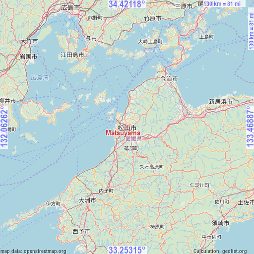
Matsuyama GPS coordinates[2]
33° 50' 20.976" North, 132° 45' 56.664" East
| Map corner | latitude | longitude |
|---|---|---|
| Upper-left | 34.42118°, | 132.06262° |
| Center: | 33.83916°, | 132.76574° |
| Lower-right: | 33.25315°, | 133.46887° |
| Map W x H: | 129.9×129.9 km | = 80.7×80.7mi |
| max Lat: | 45.40944° ⇑81.7% North |
| Matsuyama: | 33.83916° |
| min Lat: | ⇓18.3% South 24.34478° |
| min Long | Matsuyama | max Long |
| 123° | 132.76574° | 145.575° |
| W 19.6%⇐ | ⇒80.4% E |
Elevation
Elevation of Matsuyama is 28 m = 92 ft, and this is 56.6 m = 186 ft below average elevation for this country.
| Max E: |
1086 m = 3563 ft | 50.1% |
| Avg. | 84.6 m = 278 ft | |
| Matsuyama | 28 m = 92 ft | |
Min E: |
-2 m = -7 ft | 49.9% |
See also: Matsuyama elevation on elevation.city.
Geographical zone
Matsuyama is located in North temperate zone (between Tropic of Cancer and the Arctic Circle). Distance of this Northern Tropic circle is 1156.6 km =718.7 mi to South.| Distance of | km | miles | from Matsuyama |
|---|---|---|---|
| North Pole | 6244.5 | 3880.2 | to North |
| Arctic Circle | 3638.6 | 2260.9 | to North |
| Tropic Cancer | 1156.6 | 718.7 | to South |
| Equator | 3762.6 | 2338 | to South |


Nearby cities:
15 places around Matsuyama: (largest is in red/bold)
• Etajima
51.6 km =32.1 mi,  329°
329°
• Hōjō
15.3 km =9.5 mi,  4°
4°
• Ikata-chō
54.5 km =33.9 mi,  224°
224°
• Imabari-shi
33.6 km =20.9 mi,  40°
40°
• Iyo
11.4 km =7.1 mi,  211°
211°
• Kure
47.4 km =29.5 mi,  337°
337°
• Masaki-chō
7.6 km =4.7 mi, 221°
• Niihama
51.6 km =32.1 mi,  74°
74°
• Saijō
39.5 km =24.5 mi,  77°
77°
• Seiyo
51.7 km =32.1 mi,  193°
193°
• Takehara
57.2 km =35.5 mi,  14°
14°
• Tōon
12.5 km =7.8 mi,  113°
113°
• Yanai
61.6 km =38.3 mi,  283°
283°
• Yawatahama
52.5 km =32.6 mi, 215°
• Ōzu
42.7 km =26.5 mi, 207°
Sources, notices
• [Note1] Compared only with cities in Japan existing in our database
• [Src1] Map data: © OpenStreetMap contributors (CC-BY-SA)
• [Src2] Other city data from geonames.org with taken over terms of usage.
• [Src3] Geographical zone / Annual Mean Temperature by Robert A. Rohde @ Wikipedia
