Saijō geodata
Saijō (Ehime) is a seat of a second-order administrative division; located in Japan in Asia/Tokyo (GMT+9) time zone. With population of 58,823 people, there are 330 cities with bigger population in this country. Compared to other cities in Japan, 81.3% of cities are located further ↑North; 79% of cities are located further →East and 79% of cities have higher elevation than Saijō. Note1


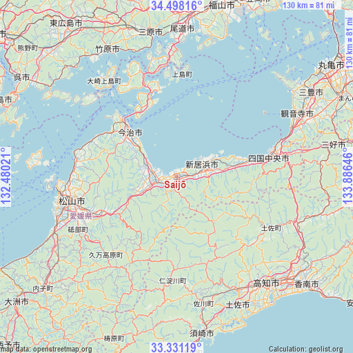
Saijō GPS coordinates[2]
33° 55' 0.012" North, 133° 10' 59.988" East
| Map corner | latitude | longitude |
|---|---|---|
| Upper-left | 34.49816°, | 132.48021° |
| Center: | 33.91667°, | 133.18333° |
| Lower-right: | 33.33119°, | 133.88646° |
| Map W x H: | 129.8×129.8 km | = 80.7×80.7mi |
| max Lat: | 45.40944° ⇑81.3% North |
| Saijō: | 33.91667° |
| min Lat: | ⇓18.7% South 24.34478° |
| min Long | Saijō | max Long |
| 123° | 133.18333° | 145.575° |
| W 21%⇐ | ⇒79% E |
Elevation
Elevation of Saijō is 8 m = 26 ft, and this is 76.6 m = 251 ft below average elevation for this country.
| Max E: |
1086 m = 3563 ft | 79% |
| Avg. | 84.6 m = 278 ft | |
| Saijō | 8 m = 26 ft | |
Min E: |
-2 m = -7 ft | 21% |
See also: Saijō elevation on elevation.city.
Geographical zone
Saijō is located in North temperate zone (between Tropic of Cancer and the Arctic Circle). Distance of this Northern Tropic circle is 1165.3 km =724.1 mi to South.| Distance of | km | miles | from Saijō |
|---|---|---|---|
| North Pole | 6235.9 | 3874.8 | to North |
| Arctic Circle | 3630 | 2255.6 | to North |
| Tropic Cancer | 1165.3 | 724.1 | to South |
| Equator | 3771.2 | 2343.3 | to South |


Nearby cities:
15 places around Saijō: (largest is in red/bold)
• Hōjō
38 km =23.6 mi,  280°
280°
• Imabari-shi
24 km =14.9 mi,  315°
315°
• Innoshima
40.8 km =25.4 mi,  0°
0°
• Ino
46.9 km =29.1 mi,  150°
150°
• Iyo
48.2 km =30 mi,  247°
247°
• Kan’onji
46.2 km =28.7 mi,  68°
68°
• Kan’onjichō
48.7 km =30.3 mi,  61°
61°
• Kawanoechō
38.1 km =23.7 mi, 73°
• Kochi
52.1 km =32.4 mi,  141°
141°
• Masaki-chō
45.9 km =28.5 mi, 251°
• Matsuyama
39.5 km =24.5 mi,  257°
257°
• Niihama
12.3 km =7.6 mi, 66°
• Shikokuchūō
34.4 km =21.4 mi,  79°
79°
• Tosa
51.8 km =32.2 mi, 152°
• Tōon
30.3 km =18.8 mi,  243°
243°
Sources, notices
• [Note1] Compared only with cities in Japan existing in our database
• [Src1] Map data: © OpenStreetMap contributors (CC-BY-SA)
• [Src2] Other city data from geonames.org with taken over terms of usage.
• [Src3] Geographical zone / Annual Mean Temperature by Robert A. Rohde @ Wikipedia
