Kazo geodata
Kazo (Saitama) is a seat of a second-order administrative division; located in Japan in Asia/Tokyo (GMT+9) time zone. With population of 71,291 people, there are 273 cities with bigger population in this country. Compared to other cities in Japan, 70% of cities are located further ↓South; 71.5% of cities are located further ←West and 69.3% of cities have higher elevation than Kazo. Note1


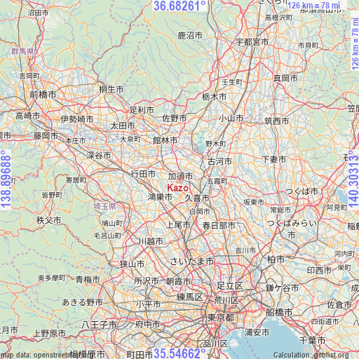
Kazo GPS coordinates[2]
36° 7' 0.012" North, 139° 36' 0" East
| Map corner | latitude | longitude |
|---|---|---|
| Upper-left | 36.68261°, | 138.89688° |
| Center: | 36.11667°, | 139.6° |
| Lower-right: | 35.54662°, | 140.30313° |
| Map W x H: | 126.3×126.3 km | = 78.5×78.5mi |
| max Lat: | 45.40944° ⇑30% North |
| Kazo: | 36.11667° |
| min Lat: | ⇓70% South 24.34478° |
| min Long | Kazo | max Long |
| 123° | 139.6° | 145.575° |
| W 71.5%⇐ | ⇒28.5% E |
Elevation
Elevation of Kazo is 12 m = 39 ft, and this is 72.6 m = 238 ft below average elevation for this country.
| Max E: |
1086 m = 3563 ft | 69.3% |
| Avg. | 84.6 m = 278 ft | |
| Kazo | 12 m = 39 ft | |
Min E: |
-2 m = -7 ft | 30.7% |
See also: Kazo elevation on elevation.city.
Geographical zone
Kazo is located in North temperate zone (between Tropic of Cancer and the Arctic Circle). Distance of this Northern Tropic circle is 1409.9 km =876.1 mi to South.| Distance of | km | miles | from Kazo |
|---|---|---|---|
| North Pole | 5991.3 | 3722.8 | to North |
| Arctic Circle | 3385.4 | 2103.6 | to North |
| Tropic Cancer | 1409.9 | 876.1 | to South |
| Equator | 4015.8 | 2495.3 | to South |


Nearby cities:
15 places around Kazo: (largest is in red/bold)
• Fujioka
15.5 km =9.6 mi,  16°
16°
• Fukiage-fujimi
13.6 km =8.5 mi,  262°
262°
• Gyōda
12.8 km =8 mi,  282°
282°
• Hanyū
8.2 km =5.1 mi,  312°
312°
• Kisai
2.4 km =1.5 mi,  218°
218°
• Kitamoto
10.8 km =6.7 mi,  211°
211°
• Koga
12.8 km =8 mi,  54°
54°
• Kukichūō
8.7 km =5.4 mi,  129°
129°
• Kurihashi
9.2 km =5.7 mi,  78°
78°
• Kōnosu
9.2 km =5.7 mi,  234°
234°
• Okegawa
13.5 km =8.4 mi,  196°
196°
• Satte
12.4 km =7.7 mi,  113°
113°
• Shiraoka
12.2 km =7.6 mi,  153°
153°
• Shōbu
5.6 km =3.5 mi,  180°
180°
• Sugito
14.8 km =9.2 mi, 129°
Sources, notices
• [Note1] Compared only with cities in Japan existing in our database
• [Src1] Map data: © OpenStreetMap contributors (CC-BY-SA)
• [Src2] Other city data from geonames.org with taken over terms of usage.
• [Src3] Geographical zone / Annual Mean Temperature by Robert A. Rohde @ Wikipedia
