Shōbu geodata
Shōbu (Saitama) is a populated place; located in Japan in Asia/Tokyo (GMT+9) time zone. With population of 22,156 people, there are 658 cities with bigger population in this country. Compared to other cities in Japan, 69% of cities are located further ↓South; 71.5% of cities are located further ←West and 68.3% of cities have higher elevation than Shōbu. Note1


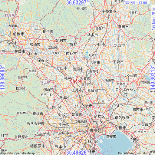
Shōbu GPS coordinates[2]
36° 4' 0.012" North, 139° 36' 0" East
| Map corner | latitude | longitude |
|---|---|---|
| Upper-left | 36.63297°, | 138.89688° |
| Center: | 36.06667°, | 139.6° |
| Lower-right: | 35.49626°, | 140.30313° |
| Map W x H: | 126.4×126.4 km | = 78.5×78.5mi |
| max Lat: | 45.40944° ⇑31% North |
| Shōbu: | 36.06667° |
| min Lat: | ⇓69% South 24.34478° |
| min Long | Shōbu | max Long |
| 123° | 139.6° | 145.575° |
| W 71.5%⇐ | ⇒28.5% E |
Elevation
Elevation of Shōbu is 13 m = 43 ft, and this is 71.6 m = 235 ft below average elevation for this country.
| Max E: |
1086 m = 3563 ft | 68.3% |
| Avg. | 84.6 m = 278 ft | |
| Shōbu | 13 m = 43 ft | |
Min E: |
-2 m = -7 ft | 31.7% |
See also: Japan elevation on elevation.city.
Geographical zone
Shōbu is located in North temperate zone (between Tropic of Cancer and the Arctic Circle). Distance of this Northern Tropic circle is 1404.3 km =872.6 mi to South.| Distance of | km | miles | from Shōbu |
|---|---|---|---|
| North Pole | 5996.8 | 3726.2 | to North |
| Arctic Circle | 3390.9 | 2107 | to North |
| Tropic Cancer | 1404.3 | 872.6 | to South |
| Equator | 4010.2 | 2491.8 | to South |


Nearby cities:
15 places around Shōbu: (largest is in red/bold)
• Ageoshimo
10.7 km =6.6 mi,  173°
173°
• Fukiage-fujimi
14 km =8.7 mi,  285°
285°
• Hanyū
12.6 km =7.8 mi,  331°
331°
• Hasuda
11.5 km =7.1 mi,  157°
157°
• Iwatsuki
14.3 km =8.9 mi,  142°
142°
• Kazo
5.6 km =3.5 mi,  0°
0°
• Kisai
4 km =2.5 mi,  337°
337°
• Kitamoto
6.7 km =4.2 mi,  236°
236°
• Kukichūō
6.7 km =4.2 mi,  89°
89°
• Kurihashi
11.6 km =7.2 mi,  50°
50°
• Kōnosu
7.5 km =4.7 mi,  271°
271°
• Okegawa
8.4 km =5.2 mi,  207°
207°
• Satte
11.4 km =7.1 mi, 86°
• Shiraoka
7.6 km =4.7 mi,  134°
134°
• Sugito
12 km =7.5 mi,  109°
109°
Sources, notices
• [Note1] Compared only with cities in Japan existing in our database
• [Src1] Map data: © OpenStreetMap contributors (CC-BY-SA)
• [Src2] Other city data from geonames.org with taken over terms of usage.
• [Src3] Geographical zone / Annual Mean Temperature by Robert A. Rohde @ Wikipedia
