Tokuyama geodata
Tokuyama (Yamaguchi) is a populated place; located in Japan in Asia/Tokyo (GMT+9) time zone. With population of 101,133 people, there are 198 cities with bigger population in this country. Compared to other cities in Japan, 79.7% of cities are located further ↑North; 83.2% of cities are located further →East and 54.9% of cities have lower elevation than Tokuyama. Note1


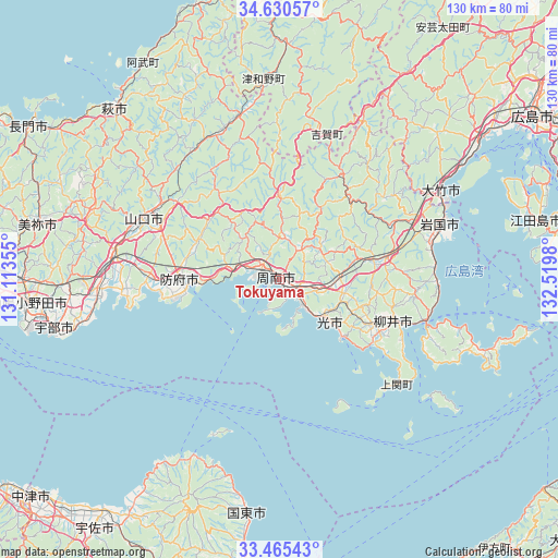
Tokuyama GPS coordinates[2]
34° 3' 0" North, 131° 49' 0.012" East
| Map corner | latitude | longitude |
|---|---|---|
| Upper-left | 34.63057°, | 131.11355° |
| Center: | 34.05°, | 131.81667° |
| Lower-right: | 33.46543°, | 132.5198° |
| Map W x H: | 129.6×129.6 km | = 80.5×80.5mi |
| max Lat: | 45.40944° ⇑79.7% North |
| Tokuyama: | 34.05° |
| min Lat: | ⇓20.3% South 24.34478° |
| min Long | Tokuyama | max Long |
| 123° | 131.81667° | 145.575° |
| W 16.8%⇐ | ⇒83.2% E |
Elevation
Elevation of Tokuyama is 35 m = 115 ft, and this is 49.6 m = 163 ft below average elevation for this country.
| Max E: |
1086 m = 3563 ft | 45.1% |
| Avg. | 84.6 m = 278 ft | |
| Tokuyama | 35 m = 115 ft | |
Min E: |
-2 m = -7 ft | 54.9% |
See also: Tokuyama elevation on elevation.city.
Geographical zone
Tokuyama is located in North temperate zone (between Tropic of Cancer and the Arctic Circle). Distance of this Northern Tropic circle is 1180.1 km =733.3 mi to South.| Distance of | km | miles | from Tokuyama |
|---|---|---|---|
| North Pole | 6221.1 | 3865.6 | to North |
| Arctic Circle | 3615.2 | 2246.4 | to North |
| Tropic Cancer | 1180.1 | 733.3 | to South |
| Equator | 3786 | 2352.5 | to South |


Nearby cities:
15 places around Tokuyama: (largest is in red/bold)
• Hagi
53.5 km =33.2 mi,  316°
316°
• Hikari
16.2 km =10.1 mi,  130°
130°
• Hōfu
23 km =14.3 mi,  270°
270°
• Iwakuni
39.2 km =24.4 mi,  71°
71°
• Kudamatsu
7.2 km =4.5 mi,  140°
140°
• Kunisaki
55.7 km =34.6 mi,  188°
188°
• Mine
57.3 km =35.6 mi,  285°
285°
• Miyajima
54.1 km =33.6 mi,  59°
59°
• Ogōri-shimogō
38.8 km =24.1 mi,  278°
278°
• Shūnan
3.5 km =2.2 mi,  13°
13°
• Ube
53.5 km =33.2 mi,  257°
257°
• Yamaguchi
35.5 km =22.1 mi, 294°
• Yanai
29.2 km =18.1 mi,  108°
108°
• Ōno-hara
48.9 km =30.4 mi, 57°
• Ōtake
41.1 km =25.5 mi, 64°
Sources, notices
• [Note1] Compared only with cities in Japan existing in our database
• [Src1] Map data: © OpenStreetMap contributors (CC-BY-SA)
• [Src2] Other city data from geonames.org with taken over terms of usage.
• [Src3] Geographical zone / Annual Mean Temperature by Robert A. Rohde @ Wikipedia
