Shūnan geodata
Shūnan (Yamaguchi) is a seat of a second-order administrative division; located in Japan in Asia/Tokyo (GMT+9) time zone. In our database, there are 767 cities with bigger population. Compared to other cities in Japan, 78.8% of cities are located further ↑North; 83.1% of cities are located further →East and 93.6% of cities have lower elevation than Shūnan. Note1


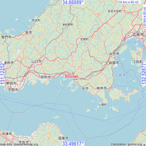
Shūnan GPS coordinates[2]
34° 4' 49.908" North, 131° 49' 32.304" East
| Map corner | latitude | longitude |
|---|---|---|
| Upper-left | 34.66089°, | 131.12252° |
| Center: | 34.08053°, | 131.82564° |
| Lower-right: | 33.49617°, | 132.52877° |
| Map W x H: | 129.5×129.5 km | = 80.5×80.5mi |
| max Lat: | 45.40944° ⇑78.8% North |
| Shūnan: | 34.08053° |
| min Lat: | ⇓21.2% South 24.34478° |
| min Long | Shūnan | max Long |
| 123° | 131.82564° | 145.575° |
| W 16.9%⇐ | ⇒83.1% E |
Elevation
Elevation of Shūnan is 316 m = 1037 ft, and this is 231.4 m = 759 ft above average elevation for this country.
| Max E: |
1086 m = 3563 ft | 6.4% |
| Shūnan | 316 m 1037 ft | |
| Avg. | 84.6 m = 278 ft | |
Min E: |
-2 m = -7 ft | 93.6% |
See also: Japan elevation on elevation.city.
Geographical zone
Shūnan is located in North temperate zone (between Tropic of Cancer and the Arctic Circle). Distance of this Northern Tropic circle is 1183.5 km =735.4 mi to South.| Distance of | km | miles | from Shūnan |
|---|---|---|---|
| North Pole | 6217.7 | 3863.5 | to North |
| Arctic Circle | 3611.8 | 2244.3 | to North |
| Tropic Cancer | 1183.5 | 735.4 | to South |
| Equator | 3789.4 | 2354.6 | to South |


Nearby cities:
15 places around Shūnan: (largest is in red/bold)
• Hagi
51.7 km =32.1 mi,  313°
313°
• Hatsukaichi
55.5 km =34.5 mi,  57°
57°
• Hikari
18.1 km =11.2 mi,  140°
140°
• Hōfu
24.1 km =15 mi,  261°
261°
• Iwakuni
37.4 km =23.2 mi,  75°
75°
• Kudamatsu
9.7 km =6 mi,  157°
157°
• Mine
57.3 km =35.6 mi,  281°
281°
• Miyajima
51.7 km =32.1 mi, 61°
• Ogōri-shimogō
39.3 km =24.4 mi,  273°
273°
• Tokuyama
3.5 km =2.2 mi,  193°
193°
• Ube
55.1 km =34.2 mi,  253°
253°
• Yamaguchi
35 km =21.7 mi,  289°
289°
• Yanai
29.7 km =18.5 mi,  115°
115°
• Ōno-hara
46.4 km =28.8 mi, 60°
• Ōtake
39 km =24.2 mi,  68°
68°
Sources, notices
• [Note1] Compared only with cities in Japan existing in our database
• [Src1] Map data: © OpenStreetMap contributors (CC-BY-SA)
• [Src2] Other city data from geonames.org with taken over terms of usage.
• [Src3] Geographical zone / Annual Mean Temperature by Robert A. Rohde @ Wikipedia
