Aira geodata
Aira (Kagoshima) is a seat of a second-order administrative division; located in Japan in Asia/Tokyo (GMT+9) time zone. In our database, there are 767 cities with bigger population. Compared to other cities in Japan, 95.4% of cities are located further ↑North; 91.3% of cities are located further →East and 70.7% of cities have lower elevation than Aira. Note1


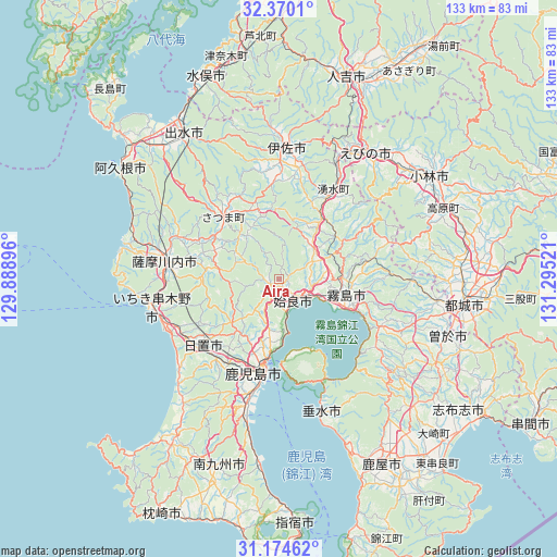
Aira GPS coordinates[2]
31° 46' 27.444" North, 130° 35' 31.488" East
| Map corner | latitude | longitude |
|---|---|---|
| Upper-left | 32.3701°, | 129.88896° |
| Center: | 31.77429°, | 130.59208° |
| Lower-right: | 31.17462°, | 131.29521° |
| Map W x H: | 132.9×132.9 km | = 82.6×82.6mi |
| max Lat: | 45.40944° ⇑95.4% North |
| Aira: | 31.77429° |
| min Lat: | ⇓4.6% South 24.34478° |
| min Long | Aira | max Long |
| 123° | 130.59208° | 145.575° |
| W 8.7%⇐ | ⇒91.3% E |
Elevation
Elevation of Aira is 76 m = 249 ft, and this is 8.6 m = 28 ft below average elevation for this country.
| Max E: |
1086 m = 3563 ft | 29.3% |
| Avg. | 84.6 m = 278 ft | |
| Aira | 76 m = 249 ft | |
Min E: |
-2 m = -7 ft | 70.7% |
See also: Japan elevation on elevation.city.
Geographical zone
Aira is located in North temperate zone (between Tropic of Cancer and the Arctic Circle). Distance of this Northern Tropic circle is 927.1 km =576.1 mi to South.| Distance of | km | miles | from Aira |
|---|---|---|---|
| North Pole | 6474.1 | 4022.8 | to North |
| Arctic Circle | 3868.2 | 2403.6 | to North |
| Tropic Cancer | 927.1 | 576.1 | to South |
| Equator | 3533 | 2195.3 | to South |


Nearby cities:
15 places around Aira: (largest is in red/bold)
• Ebino
38.6 km =24 mi,  38°
38°
• Hamanoichi
14.8 km =9.2 mi,  115°
115°
• Hioki
31.2 km =19.4 mi,  227°
227°
• Ichikikushikino
28.7 km =17.8 mi,  259°
259°
• Ijūin
25.2 km =15.7 mi, 226°
• Isa
32.6 km =20.3 mi,  3°
3°
• Kagoshima
23.4 km =14.5 mi,  189°
189°
• Kajiki
8.4 km =5.2 mi, 122°
• Kirishima
16.6 km =10.3 mi,  102°
102°
• Kokubu-matsuki
17.1 km =10.6 mi,  105°
105°
• Kushikino
31.4 km =19.5 mi, 258°
• Satsumasendai
28 km =17.4 mi,  279°
279°
• Tarumizu
33.9 km =21.1 mi,  162°
162°
• Yotsueda
29.9 km =18.6 mi,  26°
26°
• Ōkuchi-shinohara
32.8 km =20.4 mi,  5°
5°
Sources, notices
• [Note1] Compared only with cities in Japan existing in our database
• [Src1] Map data: © OpenStreetMap contributors (CC-BY-SA)
• [Src2] Other city data from geonames.org with taken over terms of usage.
• [Src3] Geographical zone / Annual Mean Temperature by Robert A. Rohde @ Wikipedia
