Satsumasendai geodata
Satsumasendai (Kagoshima) is a seat of a second-order administrative division; located in Japan in Asia/Tokyo (GMT+9) time zone. With population of 73,132 people, there are 269 cities with bigger population in this country. Compared to other cities in Japan, 95.3% of cities are located further ↑North; 95.1% of cities are located further →East and 89.6% of cities have higher elevation than Satsumasendai. Note1


Satsumasendai GPS coordinates[2]
31° 49' 0.012" North, 130° 18' 0" East
| Map corner | latitude | longitude |
|---|---|---|
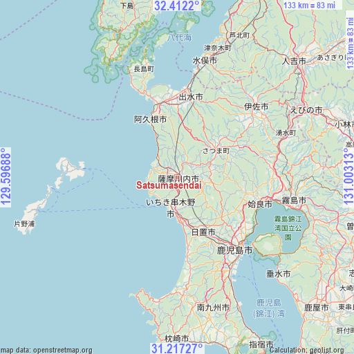
| Upper-left | 32.4122°, | 129.59688° |
| Center: | 31.81667°, | 130.3° |
| Lower-right: | 31.21727°, | 131.00313° |
| Map W x H: | 132.9×132.9 km | = 82.6×82.6mi |
| max Lat: | 45.40944° ⇑95.3% North |
| Satsumasendai: | 31.81667° |
| min Lat: | ⇓4.7% South 24.34478° |
| min Long | Satsumasendai | max Long |
| 123° | 130.3° | 145.575° |
| W 4.9%⇐ | ⇒95.1% E |
Elevation
Elevation of Satsumasendai is 5 m = 16 ft, and this is 79.6 m = 261 ft below average elevation for this country.
| Max E: |
1086 m = 3563 ft | 89.6% |
| Avg. | 84.6 m = 278 ft | |
| Satsumasendai | 5 m = 16 ft | |
Min E: |
-2 m = -7 ft | 10.4% |
See also: Satsumasendai elevation on elevation.city.
Geographical zone
Satsumasendai is located in North temperate zone (between Tropic of Cancer and the Arctic Circle). Distance of this Northern Tropic circle is 931.8 km =579 mi to South.| Distance of | km | miles | from Satsumasendai |
|---|---|---|---|
| North Pole | 6469.4 | 4019.9 | to North |
| Arctic Circle | 3863.5 | 2400.7 | to North |
| Tropic Cancer | 931.8 | 579 | to South |
| Equator | 3537.7 | 2198.2 | to South |


Nearby cities:
15 places around Satsumasendai: (largest is in red/bold)
• Aira
28 km =17.4 mi,  99°
99°
• Akune
24.2 km =15 mi,  337°
337°
• Hamanoichi
42.4 km =26.3 mi,  105°
105°
• Hioki
26.4 km =16.4 mi,  169°
169°
• Ichikikushikino
9.7 km =6 mi,  183°
183°
• Ijūin
24.2 km =15 mi,  156°
156°
• Isa
40.5 km =25.2 mi,  46°
46°
• Izumi
30.3 km =18.8 mi,  11°
11°
• Kagoshima
36.5 km =22.7 mi,  139°
139°
• Kajiki
35.9 km =22.3 mi, 104°
• Kaseda-shirakame
44.5 km =27.7 mi, 177°
• Kirishima
44.6 km =27.7 mi, 100°
• Kokubu-matsuki
45.1 km =28 mi, 101°
• Kushikino
11.6 km =7.2 mi,  195°
195°
• Ōkuchi-shinohara
41.4 km =25.7 mi, 47°
In other languages:
- In Spanish: Sendai
- In France: Sendai
- In German: Sendai
- In Italian: Sendai
- In Russian: Сендай, Сацумасендай
- In Chinese: 薩摩川內市
Sources, notices
• [Note1] Compared only with cities in Japan existing in our database
• [Src1] Map data: © OpenStreetMap contributors (CC-BY-SA)
• [Src2] Other city data from geonames.org with taken over terms of usage.
• [Src3] Geographical zone / Annual Mean Temperature by Robert A. Rohde @ Wikipedia
