Kushikino geodata
Kushikino (Kagoshima) is a populated place; located in Japan in Asia/Tokyo (GMT+9) time zone. With population of 25,744 people, there are 603 cities with bigger population in this country. Compared to other cities in Japan, 96.1% of cities are located further ↑North; 95.5% of cities are located further →East and 86% of cities have higher elevation than Kushikino. Note1


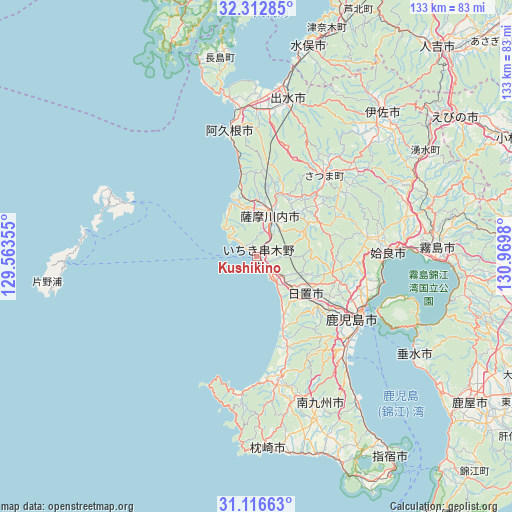
Kushikino GPS coordinates[2]
31° 43' 0.012" North, 130° 16' 0.012" East
| Map corner | latitude | longitude |
|---|---|---|
| Upper-left | 32.31285°, | 129.56355° |
| Center: | 31.71667°, | 130.26667° |
| Lower-right: | 31.11663°, | 130.9698° |
| Map W x H: | 133×133 km | = 82.6×82.6mi |
| max Lat: | 45.40944° ⇑96.1% North |
| Kushikino: | 31.71667° |
| min Lat: | ⇓3.9% South 24.34478° |
| min Long | Kushikino | max Long |
| 123° | 130.26667° | 145.575° |
| W 4.5%⇐ | ⇒95.5% E |
Elevation
Elevation of Kushikino is 6 m = 20 ft, and this is 78.6 m = 258 ft below average elevation for this country.
| Max E: |
1086 m = 3563 ft | 86% |
| Avg. | 84.6 m = 278 ft | |
| Kushikino | 6 m = 20 ft | |
Min E: |
-2 m = -7 ft | 14% |
See also: Japan elevation on elevation.city.
Geographical zone
Kushikino is located in North temperate zone (between Tropic of Cancer and the Arctic Circle). Distance of this Northern Tropic circle is 920.6 km =572 mi to South.| Distance of | km | miles | from Kushikino |
|---|---|---|---|
| North Pole | 6480.5 | 4026.8 | to North |
| Arctic Circle | 3874.6 | 2407.6 | to North |
| Tropic Cancer | 920.6 | 572 | to South |
| Equator | 3526.6 | 2191.3 | to South |


Nearby cities:
15 places around Kushikino: (largest is in red/bold)
• Aira
31.4 km =19.5 mi,  78°
78°
• Akune
33.9 km =21.1 mi,  349°
349°
• Hamanoichi
44.1 km =27.4 mi,  90°
90°
• Hioki
16.8 km =10.4 mi,  151°
151°
• Ichikikushikino
2.9 km =1.8 mi,  60°
60°
• Ijūin
16.8 km =10.4 mi,  131°
131°
• Izumi
41.8 km =26 mi,  13°
13°
• Kagoshima
31.6 km =19.6 mi,  121°
121°
• Kajiki
37.9 km =23.5 mi, 87°
• Kaseda-shirakame
33.7 km =20.9 mi,  171°
171°
• Kirishima
47 km =29.2 mi, 86°
• Kokubu-matsuki
47.3 km =29.4 mi, 87°
• Minamikyushu
44.9 km =27.9 mi,  156°
156°
• Minamisatsuma
36.4 km =22.6 mi,  177°
177°
• Satsumasendai
11.6 km =7.2 mi,  15°
15°
Sources, notices
• [Note1] Compared only with cities in Japan existing in our database
• [Src1] Map data: © OpenStreetMap contributors (CC-BY-SA)
• [Src2] Other city data from geonames.org with taken over terms of usage.
• [Src3] Geographical zone / Annual Mean Temperature by Robert A. Rohde @ Wikipedia
