Kariya geodata
Kariya (Hyōgo) is a populated place; located in Japan in Asia/Tokyo (GMT+9) time zone. With population of 52,015 people, there are 362 cities with bigger population in this country. Compared to other cities in Japan, 66.8% of cities are located further ↑North; 73.3% of cities are located further →East and 89.6% of cities have higher elevation than Kariya. Note1


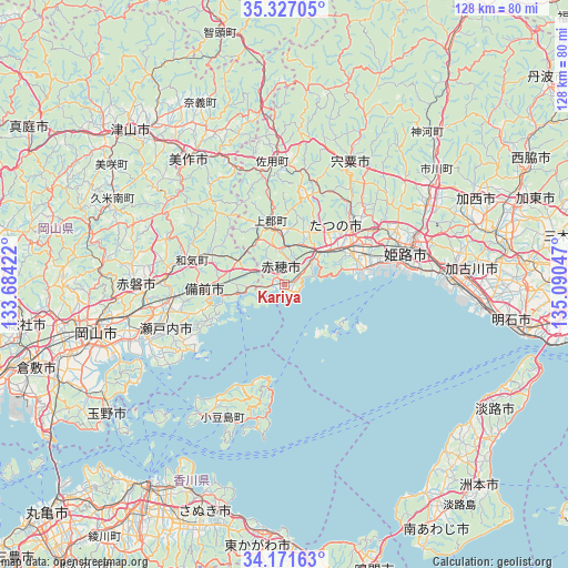
Kariya GPS coordinates[2]
34° 45' 4.896" North, 134° 23' 14.424" East
| Map corner | latitude | longitude |
|---|---|---|
| Upper-left | 35.32705°, | 133.68422° |
| Center: | 34.75136°, | 134.38734° |
| Lower-right: | 34.17163°, | 135.09047° |
| Map W x H: | 128.5×128.5 km | = 79.8×79.8mi |
| max Lat: | 45.40944° ⇑66.8% North |
| Kariya: | 34.75136° |
| min Lat: | ⇓33.2% South 24.34478° |
| min Long | Kariya | max Long |
| 123° | 134.38734° | 145.575° |
| W 26.7%⇐ | ⇒73.3% E |
Elevation
Elevation of Kariya is 5 m = 16 ft, and this is 79.6 m = 261 ft below average elevation for this country.
| Max E: |
1086 m = 3563 ft | 89.6% |
| Avg. | 84.6 m = 278 ft | |
| Kariya | 5 m = 16 ft | |
Min E: |
-2 m = -7 ft | 10.4% |
See also: Kariya elevation on elevation.city.
Geographical zone
Kariya is located in North temperate zone (between Tropic of Cancer and the Arctic Circle). Distance of this Northern Tropic circle is 1258.1 km =781.7 mi to South.| Distance of | km | miles | from Kariya |
|---|---|---|---|
| North Pole | 6143.1 | 3817.1 | to North |
| Arctic Circle | 3537.2 | 2197.9 | to North |
| Tropic Cancer | 1258.1 | 781.7 | to South |
| Equator | 3864 | 2401 | to South |


Nearby cities:
15 places around Kariya: (largest is in red/bold)
• Aioi
9.4 km =5.8 mi,  51°
51°
• Akaiwa
34 km =21.1 mi,  281°
281°
• Ako
1.8 km =1.1 mi,  300°
300°
• Bizen
14.4 km =8.9 mi,  285°
285°
• Himeji
29.5 km =18.3 mi,  75°
75°
• Mimasaka
35.5 km =22.1 mi,  335°
335°
• Setouchi
24.6 km =15.3 mi,  245°
245°
• Shirahamachō-usazakiminami
30.3 km =18.8 mi, 83°
• Shisō
30.2 km =18.8 mi,  32°
32°
• Takasago
37 km =23 mi,  87°
87°
• Tatsuno
16.8 km =10.4 mi,  57°
57°
• Tatsunochō-tominaga
19.6 km =12.2 mi, 50°
• Tonoshō
36.1 km =22.4 mi,  213°
213°
• Yamazakichō-nakabirose
31.4 km =19.5 mi, 28°
• Yonedacho Sendo
40.1 km =24.9 mi, 86°
Sources, notices
• [Note1] Compared only with cities in Japan existing in our database
• [Src1] Map data: © OpenStreetMap contributors (CC-BY-SA)
• [Src2] Other city data from geonames.org with taken over terms of usage.
• [Src3] Geographical zone / Annual Mean Temperature by Robert A. Rohde @ Wikipedia
