Gojō geodata
Gojō (Nara) is a seat of a second-order administrative division; located in Japan in Asia/Tokyo (GMT+9) time zone. With population of 34,342 people, there are 505 cities with bigger population in this country. Compared to other cities in Japan, 74.9% of cities are located further ↑North; 64.3% of cities are located further →East and 75.7% of cities have lower elevation than Gojō. Note1


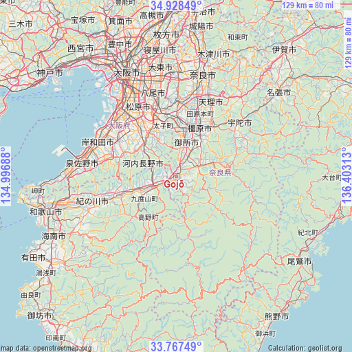
Gojō GPS coordinates[2]
34° 21' 0" North, 135° 42' 0" East
| Map corner | latitude | longitude |
|---|---|---|
| Upper-left | 34.92849°, | 134.99688° |
| Center: | 34.35°, | 135.7° |
| Lower-right: | 33.76749°, | 136.40313° |
| Map W x H: | 129.1×129.1 km | = 80.2×80.2mi |
| max Lat: | 45.40944° ⇑74.9% North |
| Gojō: | 34.35° |
| min Lat: | ⇓25.1% South 24.34478° |
| min Long | Gojō | max Long |
| 123° | 135.7° | 145.575° |
| W 35.7%⇐ | ⇒64.3% E |
Elevation
Elevation of Gojō is 98 m = 322 ft, and this is 13.4 m = 44 ft above average elevation for this country.
| Max E: |
1086 m = 3563 ft | 24.3% |
| Gojō | 98 m 322 ft | |
| Avg. | 84.6 m = 278 ft | |
Min E: |
-2 m = -7 ft | 75.7% |
See also: Japan elevation on elevation.city.
Geographical zone
Gojō is located in North temperate zone (between Tropic of Cancer and the Arctic Circle). Distance of this Northern Tropic circle is 1213.4 km =754 mi to South.| Distance of | km | miles | from Gojō |
|---|---|---|---|
| North Pole | 6187.7 | 3844.9 | to North |
| Arctic Circle | 3581.8 | 2225.6 | to North |
| Tropic Cancer | 1213.4 | 754 | to South |
| Equator | 3819.4 | 2373.3 | to South |


Nearby cities:
15 places around Gojō: (largest is in red/bold)
• Gose
11.5 km =7.1 mi,  15°
15°
• Habikino
24.7 km =15.3 mi,  336°
336°
• Hashimoto
8.5 km =5.3 mi,  244°
244°
• Kashiba
20.6 km =12.8 mi,  2°
2°
• Kashihara-shi
19.6 km =12.2 mi,  25°
25°
• Katsuragi
15.1 km =9.4 mi,  358°
358°
• Kawachi-Nagano
14.8 km =9.2 mi,  313°
313°
• Kōya
16.8 km =10.4 mi,  205°
205°
• Sakurai
21.6 km =13.4 mi,  39°
39°
• Tawaramoto
24.3 km =15.1 mi, 20°
• Tondabayashichō
19 km =11.8 mi,  331°
331°
• Yamato-Takada
19.1 km =11.9 mi,  13°
13°
• Yoshino-chō
15.4 km =9.6 mi,  70°
70°
• Ōsaka-sayama
21.2 km =13.2 mi,  319°
319°
• Ōuda
25 km =15.5 mi,  58°
58°
Sources, notices
• [Note1] Compared only with cities in Japan existing in our database
• [Src1] Map data: © OpenStreetMap contributors (CC-BY-SA)
• [Src2] Other city data from geonames.org with taken over terms of usage.
• [Src3] Geographical zone / Annual Mean Temperature by Robert A. Rohde @ Wikipedia
