Yoshino-chō geodata
Yoshino-chō (Nara) is a populated place; located in Japan in Asia/Tokyo (GMT+9) time zone. With population of 8,829 people, there are 748 cities with bigger population in this country. Compared to other cities in Japan, 74.5% of cities are located further ↑North; 62.3% of cities are located further →East and 84.5% of cities have lower elevation than Yoshino-chō. Note1


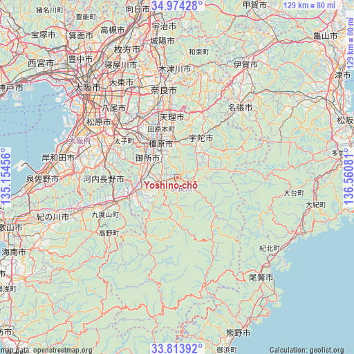
Yoshino-chō GPS coordinates[2]
34° 23' 45.996" North, 135° 51' 27.648" East
| Map corner | latitude | longitude |
|---|---|---|
| Upper-left | 34.97428°, | 135.15456° |
| Center: | 34.39611°, | 135.85768° |
| Lower-right: | 33.81392°, | 136.56081° |
| Map W x H: | 129×129 km | = 80.2×80.2mi |
| max Lat: | 45.40944° ⇑74.5% North |
| Yoshino-chō: | 34.39611° |
| min Lat: | ⇓25.5% South 24.34478° |
| min Long | Yoshino-chō | max Long |
| 123° | 135.85768° | 145.575° |
| W 37.7%⇐ | ⇒62.3% E |
Elevation
Elevation of Yoshino-chō is 165 m = 541 ft, and this is 80.4 m = 264 ft above average elevation for this country.
| Max E: |
1086 m = 3563 ft | 15.5% |
| Yoshino-chō | 165 m 541 ft | |
| Avg. | 84.6 m = 278 ft | |
Min E: |
-2 m = -7 ft | 84.5% |
See also: Japan elevation on elevation.city.
Geographical zone
Yoshino-chō is located in North temperate zone (between Tropic of Cancer and the Arctic Circle). Distance of this Northern Tropic circle is 1218.6 km =757.2 mi to South.| Distance of | km | miles | from Yoshino-chō |
|---|---|---|---|
| North Pole | 6182.6 | 3841.7 | to North |
| Arctic Circle | 3576.7 | 2222.5 | to North |
| Tropic Cancer | 1218.6 | 757.2 | to South |
| Equator | 3824.5 | 2376.4 | to South |


Nearby cities:
15 places around Yoshino-chō: (largest is in red/bold)
• Gojō
15.4 km =9.6 mi,  250°
250°
• Gose
12.9 km =8 mi,  297°
297°
• Haibara-akanedai
17.4 km =10.8 mi,  29°
29°
• Hashimoto
23.8 km =14.8 mi, 248°
• Kashiba
20.6 km =12.8 mi,  318°
318°
• Kashihara-shi
13.9 km =8.6 mi,  334°
334°
• Katsuragi
17.8 km =11.1 mi, 304°
• Kawachi-Nagano
25.7 km =16 mi,  281°
281°
• Sakurai
11.6 km =7.2 mi,  356°
356°
• Tawaramoto
18.6 km =11.6 mi,  341°
341°
• Tenri
20.9 km =13 mi,  353°
353°
• Tondabayashichō
26.2 km =16.3 mi, 296°
• Yamato-Takada
16.6 km =10.3 mi, 323°
• Yamatokōriyama
24.7 km =15.3 mi, 341°
• Ōuda
10.5 km =6.5 mi,  41°
41°
Sources, notices
• [Note1] Compared only with cities in Japan existing in our database
• [Src1] Map data: © OpenStreetMap contributors (CC-BY-SA)
• [Src2] Other city data from geonames.org with taken over terms of usage.
• [Src3] Geographical zone / Annual Mean Temperature by Robert A. Rohde @ Wikipedia
