Ōuda geodata
Ōuda (Nara) is a seat of a second-order administrative division; located in Japan in Asia/Tokyo (GMT+9) time zone. In our database, there are 767 cities with bigger population. Compared to other cities in Japan, 73.5% of cities are located further ↑North; 62% of cities are located further →East and 95.3% of cities have lower elevation than Ōuda. Note1


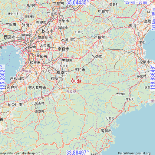
Ōuda GPS coordinates[2]
34° 28' 0.012" North, 135° 55' 59.988" East
| Map corner | latitude | longitude |
|---|---|---|
| Upper-left | 35.04435°, | 135.23021° |
| Center: | 34.46667°, | 135.93333° |
| Lower-right: | 33.88497°, | 136.63646° |
| Map W x H: | 128.9×128.9 km | = 80.1×80.1mi |
| max Lat: | 45.40944° ⇑73.5% North |
| Ōuda: | 34.46667° |
| min Lat: | ⇓26.5% South 24.34478° |
| min Long | Ōuda | max Long |
| 123° | 135.93333° | 145.575° |
| W 38%⇐ | ⇒62% E |
Elevation
Elevation of Ōuda is 372 m = 1220 ft, and this is 287.4 m = 943 ft above average elevation for this country.
| Max E: |
1086 m = 3563 ft | 4.7% |
| Ōuda | 372 m 1220 ft | |
| Avg. | 84.6 m = 278 ft | |
Min E: |
-2 m = -7 ft | 95.3% |
See also: Japan elevation on elevation.city.
Geographical zone
Ōuda is located in North temperate zone (between Tropic of Cancer and the Arctic Circle). Distance of this Northern Tropic circle is 1226.4 km =762 mi to South.| Distance of | km | miles | from Ōuda |
|---|---|---|---|
| North Pole | 6174.7 | 3836.8 | to North |
| Arctic Circle | 3568.8 | 2217.5 | to North |
| Tropic Cancer | 1226.4 | 762 | to South |
| Equator | 3832.3 | 2381.3 | to South |


Nearby cities:
15 places around Ōuda: (largest is in red/bold)
• Gojō
25 km =15.5 mi,  238°
238°
• Gose
18.4 km =11.4 mi,  264°
264°
• Haibara-akanedai
7.6 km =4.7 mi,  11°
11°
• Hōryūji
24.2 km =15 mi,  312°
312°
• Kashiba
21.9 km =13.6 mi,  290°
290°
• Kashihara-shi
13.7 km =8.5 mi, 290°
• Katsuragi
21.8 km =13.5 mi,  275°
275°
• Nabari
21.6 km =13.4 mi,  39°
39°
• Nara-shi
27 km =16.8 mi,  334°
334°
• Sakurai
8.5 km =5.3 mi,  295°
295°
• Tawaramoto
16.1 km =10 mi, 307°
• Tenri
15.9 km =9.9 mi,  324°
324°
• Yamato-Takada
17.7 km =11 mi, 288°
• Yamatokōriyama
21.6 km =13.4 mi, 316°
• Yoshino-chō
10.5 km =6.5 mi,  221°
221°
Sources, notices
• [Note1] Compared only with cities in Japan existing in our database
• [Src1] Map data: © OpenStreetMap contributors (CC-BY-SA)
• [Src2] Other city data from geonames.org with taken over terms of usage.
• [Src3] Geographical zone / Annual Mean Temperature by Robert A. Rohde @ Wikipedia
