Kanekomachi geodata
Kanekomachi (Gunma) is a populated place; located in Japan in Asia/Tokyo (GMT+9) time zone. With population of 37,107 people, there are 482 cities with bigger population in this country. Compared to other cities in Japan, 76.1% of cities are located further ↓South; 60.6% of cities are located further ←West and 87.4% of cities have lower elevation than Kanekomachi. Note1


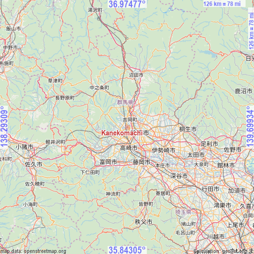
Kanekomachi GPS coordinates[2]
36° 24' 39.492" North, 138° 59' 46.356" East
| Map corner | latitude | longitude |
|---|---|---|
| Upper-left | 36.97477°, | 138.29309° |
| Center: | 36.41097°, | 138.99621° |
| Lower-right: | 35.84305°, | 139.69934° |
| Map W x H: | 125.8×125.8 km | = 78.2×78.2mi |
| max Lat: | 45.40944° ⇑23.9% North |
| Kanekomachi: | 36.41097° |
| min Lat: | ⇓76.1% South 24.34478° |
| min Long | Kanekomachi | max Long |
| 123° | 138.99621° | 145.575° |
| W 60.6%⇐ | ⇒39.4% E |
Elevation
Elevation of Kanekomachi is 193 m = 633 ft, and this is 108.4 m = 356 ft above average elevation for this country.
| Max E: |
1086 m = 3563 ft | 12.6% |
| Kanekomachi | 193 m 633 ft | |
| Avg. | 84.6 m = 278 ft | |
Min E: |
-2 m = -7 ft | 87.4% |
See also: Japan elevation on elevation.city.
Geographical zone
Kanekomachi is located in North temperate zone (between Tropic of Cancer and the Arctic Circle). Distance of this Northern Tropic circle is 1442.6 km =896.4 mi to South.| Distance of | km | miles | from Kanekomachi |
|---|---|---|---|
| North Pole | 5958.5 | 3702.4 | to North |
| Arctic Circle | 3352.7 | 2083.3 | to North |
| Tropic Cancer | 1442.6 | 896.4 | to South |
| Equator | 4048.5 | 2515.6 | to South |


Nearby cities:
15 places around Kanekomachi: (largest is in red/bold)
• Annaka
12.7 km =7.9 mi,  224°
224°
• Fujioka
19.5 km =12.1 mi,  159°
159°
• Honjō
25.9 km =16.1 mi,  137°
137°
• Isesaki
21 km =13 mi,  119°
119°
• Maebashi
7.9 km =4.9 mi,  98°
98°
• Midori
26.1 km =16.2 mi,  81°
81°
• Nakanojōmachi
24 km =14.9 mi,  324°
324°
• Numata
25.2 km =15.7 mi,  11°
11°
• Sakai-nakajima
27.8 km =17.3 mi,  125°
125°
• Shibukawa
8.1 km =5 mi,  2°
2°
• Takasaki
8.8 km =5.5 mi,  168°
168°
• Tamamura
16.4 km =10.2 mi, 138°
• Tomioka
19.5 km =12.1 mi,  206°
206°
• Yoshii
17.9 km =11.1 mi,  183°
183°
• Ōmamachō-ōmama
25.1 km =15.6 mi, 84°
Sources, notices
• [Note1] Compared only with cities in Japan existing in our database
• [Src1] Map data: © OpenStreetMap contributors (CC-BY-SA)
• [Src2] Other city data from geonames.org with taken over terms of usage.
• [Src3] Geographical zone / Annual Mean Temperature by Robert A. Rohde @ Wikipedia
