Iyo geodata
Iyo (Ehime) is a seat of a second-order administrative division; located in Japan in Asia/Tokyo (GMT+9) time zone. With population of 30,760 people, there are 542 cities with bigger population in this country. Compared to other cities in Japan, 82.5% of cities are located further ↑North; 80.7% of cities are located further →East and 66.8% of cities have higher elevation than Iyo. Note1


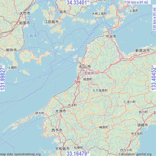
Iyo GPS coordinates[2]
33° 45' 5.004" North, 132° 42' 5.004" East
| Map corner | latitude | longitude |
|---|---|---|
| Upper-left | 34.33401°, | 131.99827° |
| Center: | 33.75139°, | 132.70139° |
| Lower-right: | 33.16479°, | 133.40452° |
| Map W x H: | 130×130 km | = 80.8×80.8mi |
| max Lat: | 45.40944° ⇑82.5% North |
| Iyo: | 33.75139° |
| min Lat: | ⇓17.5% South 24.34478° |
| min Long | Iyo | max Long |
| 123° | 132.70139° | 145.575° |
| W 19.3%⇐ | ⇒80.7% E |
Elevation
Elevation of Iyo is 14 m = 46 ft, and this is 70.6 m = 232 ft below average elevation for this country.
| Max E: |
1086 m = 3563 ft | 66.8% |
| Avg. | 84.6 m = 278 ft | |
| Iyo | 14 m = 46 ft | |
Min E: |
-2 m = -7 ft | 33.2% |
See also: Japan elevation on elevation.city.
Geographical zone
Iyo is located in North temperate zone (between Tropic of Cancer and the Arctic Circle). Distance of this Northern Tropic circle is 1146.9 km =712.7 mi to South.| Distance of | km | miles | from Iyo |
|---|---|---|---|
| North Pole | 6254.3 | 3886.2 | to North |
| Arctic Circle | 3648.4 | 2267 | to North |
| Tropic Cancer | 1146.9 | 712.7 | to South |
| Equator | 3752.8 | 2331.9 | to South |


Nearby cities:
15 places around Iyo: (largest is in red/bold)
• Etajima
57.9 km =36 mi,  339°
339°
• Hōjō
26 km =16.2 mi,  15°
15°
• Ikata-chō
43.5 km =27 mi,  227°
227°
• Imabari-shi
44.9 km =27.9 mi,  37°
37°
• Kihoku-chō
55.1 km =34.2 mi,  181°
181°
• Kure
54.9 km =34.1 mi,  346°
346°
• Masaki-chō
4.1 km =2.5 mi,  12°
12°
• Matsuyama
11.4 km =7.1 mi,  31°
31°
• Saijō
48.2 km =30 mi,  67°
67°
• Seiyo
40.9 km =25.4 mi,  189°
189°
• Tōon
18.1 km =11.2 mi, 74°
• Uwajima
60.1 km =37.3 mi, 192°
• Yanai
59.1 km =36.7 mi,  293°
293°
• Yawatahama
41.1 km =25.5 mi,  217°
217°
• Ōzu
31.3 km =19.4 mi,  206°
206°
Sources, notices
• [Note1] Compared only with cities in Japan existing in our database
• [Src1] Map data: © OpenStreetMap contributors (CC-BY-SA)
• [Src2] Other city data from geonames.org with taken over terms of usage.
• [Src3] Geographical zone / Annual Mean Temperature by Robert A. Rohde @ Wikipedia
