Masaki-chō geodata
Masaki-chō (Ehime) is a populated place; located in Japan in Asia/Tokyo (GMT+9) time zone. With population of 30,548 people, there are 544 cities with bigger population in this country. Compared to other cities in Japan, 82% of cities are located further ↑North; 80.6% of cities are located further →East and 81.8% of cities have higher elevation than Masaki-chō. Note1


Masaki-chō GPS coordinates[2]
33° 47' 15.252" North, 132° 42' 40.464" East
| Map corner | latitude | longitude |
|---|---|---|
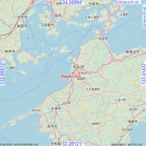
| Upper-left | 34.36994°, | 132.00812° |
| Center: | 33.78757°, | 132.71124° |
| Lower-right: | 33.20121°, | 133.41437° |
| Map W x H: | 130×130 km | = 80.8×80.8mi |
| max Lat: | 45.40944° ⇑82% North |
| Masaki-chō: | 33.78757° |
| min Lat: | ⇓18% South 24.34478° |
| min Long | Masaki-chō | max Long |
| 123° | 132.71124° | 145.575° |
| W 19.4%⇐ | ⇒80.6% E |
Elevation
Elevation of Masaki-chō is 7 m = 23 ft, and this is 77.6 m = 255 ft below average elevation for this country.
| Max E: |
1086 m = 3563 ft | 81.8% |
| Avg. | 84.6 m = 278 ft | |
| Masaki-chō | 7 m = 23 ft | |
Min E: |
-2 m = -7 ft | 18.2% |
See also: Japan elevation on elevation.city.
Geographical zone
Masaki-chō is located in North temperate zone (between Tropic of Cancer and the Arctic Circle). Distance of this Northern Tropic circle is 1150.9 km =715.1 mi to South.| Distance of | km | miles | from Masaki-chō |
|---|---|---|---|
| North Pole | 6250.2 | 3883.7 | to North |
| Arctic Circle | 3644.3 | 2264.5 | to North |
| Tropic Cancer | 1150.9 | 715.1 | to South |
| Equator | 3756.8 | 2334.4 | to South |


Nearby cities:
15 places around Masaki-chō: (largest is in red/bold)
• Etajima
54.5 km =33.9 mi,  336°
336°
• Hōjō
21.9 km =13.6 mi,  16°
16°
• Ikata-chō
46.9 km =29.1 mi,  224°
224°
• Imabari-shi
41.2 km =25.6 mi,  40°
40°
• Iyo
4.1 km =2.5 mi,  192°
192°
• Kihoku-chō
59.2 km =36.8 mi,  182°
182°
• Kure
51.2 km =31.8 mi, 344°
• Matsuyama
7.6 km =4.7 mi, 41°
• Niihama
58.1 km =36.1 mi,  70°
70°
• Saijō
45.9 km =28.5 mi, 71°
• Seiyo
45 km =28 mi, 189°
• Tōon
16.5 km =10.3 mi,  87°
87°
• Yanai
58.4 km =36.3 mi,  289°
289°
• Yawatahama
44.9 km =27.9 mi, 215°
• Ōzu
35.3 km =21.9 mi,  205°
205°
Sources, notices
• [Note1] Compared only with cities in Japan existing in our database
• [Src1] Map data: © OpenStreetMap contributors (CC-BY-SA)
• [Src2] Other city data from geonames.org with taken over terms of usage.
• [Src3] Geographical zone / Annual Mean Temperature by Robert A. Rohde @ Wikipedia
