Ōzu geodata
Ōzu (Ehime) is a seat of a second-order administrative division; located in Japan in Asia/Tokyo (GMT+9) time zone. With population of 38,833 people, there are 466 cities with bigger population in this country. Compared to other cities in Japan, 85.7% of cities are located further ↑North; 81.3% of cities are located further →East and 51.1% of cities have higher elevation than Ōzu. Note1


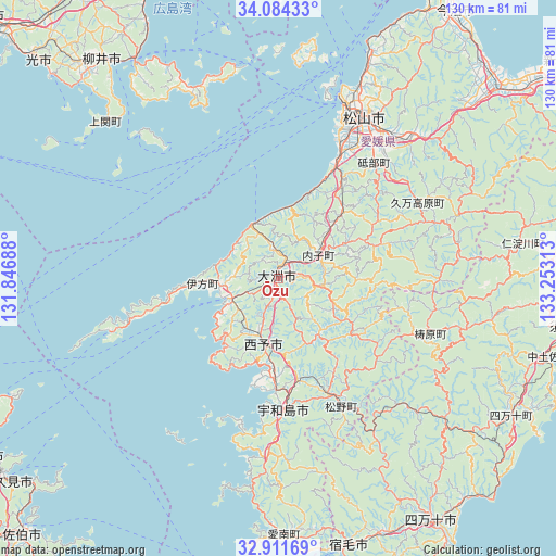
Ōzu GPS coordinates[2]
33° 30' 0" North, 132° 33' 0" East
| Map corner | latitude | longitude |
|---|---|---|
| Upper-left | 34.08433°, | 131.84688° |
| Center: | 33.5°, | 132.55° |
| Lower-right: | 32.91169°, | 133.25313° |
| Map W x H: | 130.4×130.4 km | = 81×81mi |
| max Lat: | 45.40944° ⇑85.7% North |
| Ōzu: | 33.5° |
| min Lat: | ⇓14.3% South 24.34478° |
| min Long | Ōzu | max Long |
| 123° | 132.55° | 145.575° |
| W 18.7%⇐ | ⇒81.3% E |
Elevation
Elevation of Ōzu is 27 m = 89 ft, and this is 57.6 m = 189 ft below average elevation for this country.
| Max E: |
1086 m = 3563 ft | 51.1% |
| Avg. | 84.6 m = 278 ft | |
| Ōzu | 27 m = 89 ft | |
Min E: |
-2 m = -7 ft | 48.9% |
See also: Japan elevation on elevation.city.
Geographical zone
Ōzu is located in North temperate zone (between Tropic of Cancer and the Arctic Circle). Distance of this Northern Tropic circle is 1118.9 km =695.3 mi to South.| Distance of | km | miles | from Ōzu |
|---|---|---|---|
| North Pole | 6282.2 | 3903.6 | to North |
| Arctic Circle | 3676.3 | 2284.3 | to North |
| Tropic Cancer | 1118.9 | 695.3 | to South |
| Equator | 3724.9 | 2314.5 | to South |


Nearby cities:
15 places around Ōzu: (largest is in red/bold)
• Hōjō
57 km =35.4 mi,  21°
21°
• Ikata-chō
18.2 km =11.3 mi,  265°
265°
• Iyo
31.3 km =19.4 mi,  26°
26°
• Kihoku-chō
29.8 km =18.5 mi,  155°
155°
• Masaki-chō
35.3 km =21.9 mi, 25°
• Matsuyama
42.7 km =26.5 mi, 27°
• Nakamura
67.6 km =42 mi,  148°
148°
• Seiyo
14.6 km =9.1 mi, 148°
• Shimanto
54.7 km =34 mi, 149°
• Sukumo
65.3 km =40.6 mi, 164°
• Susaki
69.8 km =43.4 mi,  99°
99°
• Tōon
45.4 km =28.2 mi,  43°
43°
• Uwajima
30.7 km =19.1 mi,  178°
178°
• Yanai
65.6 km =40.8 mi,  322°
322°
• Yawatahama
11.9 km =7.4 mi,  246°
246°
Sources, notices
• [Note1] Compared only with cities in Japan existing in our database
• [Src1] Map data: © OpenStreetMap contributors (CC-BY-SA)
• [Src2] Other city data from geonames.org with taken over terms of usage.
• [Src3] Geographical zone / Annual Mean Temperature by Robert A. Rohde @ Wikipedia
