Kuji geodata
Kuji (Iwate) is a seat of a second-order administrative division; located in Japan in Asia/Tokyo (GMT+9) time zone. In our database, there are 767 cities with bigger population. Compared to other cities in Japan, 93.3% of cities are located further ↓South; 97% of cities are located further ←West and 81.8% of cities have higher elevation than Kuji. Note1


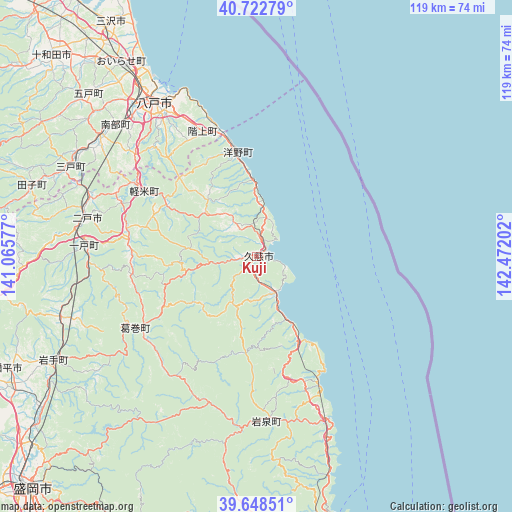
Kuji GPS coordinates[2]
40° 11' 16.008" North, 141° 46' 8.004" East
| Map corner | latitude | longitude |
|---|---|---|
| Upper-left | 40.72279°, | 141.06577° |
| Center: | 40.18778°, | 141.76889° |
| Lower-right: | 39.64851°, | 142.47202° |
| Map W x H: | 119.4×119.4 km | = 74.2×74.2mi |
| max Lat: | 45.40944° ⇑6.7% North |
| Kuji: | 40.18778° |
| min Lat: | ⇓93.3% South 24.34478° |
| min Long | Kuji | max Long |
| 123° | 141.76889° | 145.575° |
| W 97%⇐ | ⇒3% E |
Elevation
Elevation of Kuji is 7 m = 23 ft, and this is 77.6 m = 255 ft below average elevation for this country.
| Max E: |
1086 m = 3563 ft | 81.8% |
| Avg. | 84.6 m = 278 ft | |
| Kuji | 7 m = 23 ft | |
Min E: |
-2 m = -7 ft | 18.2% |
See also: Japan elevation on elevation.city.
Geographical zone
Kuji is located in North temperate zone (between Tropic of Cancer and the Arctic Circle). Distance of this Northern Tropic circle is 1862.5 km =1157.3 mi to South.| Distance of | km | miles | from Kuji |
|---|---|---|---|
| North Pole | 5538.6 | 3441.5 | to North |
| Arctic Circle | 2932.7 | 1822.3 | to North |
| Tropic Cancer | 1862.5 | 1157.3 | to South |
| Equator | 4468.5 | 2776.6 | to South |


Nearby cities:
15 places around Kuji: (largest is in red/bold)
• Furudate
54.6 km =33.9 mi,  314°
314°
• Hachimantai
63.1 km =39.2 mi,  239°
239°
• Hachinohe
41.5 km =25.8 mi,  326°
326°
• Hanawa
83.4 km =51.8 mi,  269°
269°
• Ichinohe
40.8 km =25.4 mi, 274°
• Inuotose
59.3 km =36.8 mi,  320°
320°
• Kazuno
83.7 km =52 mi, 271°
• Misawa
64.1 km =39.8 mi, 329°
• Miyako
61.9 km =38.5 mi,  166°
166°
• Morioka
75.7 km =47 mi,  224°
224°
• Ninohe
40.3 km =25 mi,  286°
286°
• Shizukuishi
86.5 km =53.7 mi,  230°
230°
• Takizawa
68.9 km =42.8 mi, 231°
• Towada
67.4 km =41.9 mi, 315°
• Yamada
81.7 km =50.8 mi, 169°
Sources, notices
• [Note1] Compared only with cities in Japan existing in our database
• [Src1] Map data: © OpenStreetMap contributors (CC-BY-SA)
• [Src2] Other city data from geonames.org with taken over terms of usage.
• [Src3] Geographical zone / Annual Mean Temperature by Robert A. Rohde @ Wikipedia
