Ōdate geodata
Ōdate (Akita) is a seat of a second-order administrative division; located in Japan in Asia/Tokyo (GMT+9) time zone. With population of 64,543 people, there are 303 cities with bigger population in this country. Compared to other cities in Japan, 93.9% of cities are located further ↓South; 88.3% of cities are located further ←West and 68% of cities have lower elevation than Ōdate. Note1


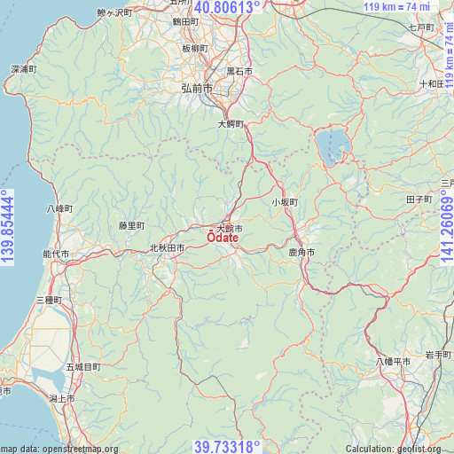
Ōdate GPS coordinates[2]
40° 16' 18.408" North, 140° 33' 27.216" East
| Map corner | latitude | longitude |
|---|---|---|
| Upper-left | 40.80613°, | 139.85444° |
| Center: | 40.27178°, | 140.55756° |
| Lower-right: | 39.73318°, | 141.26069° |
| Map W x H: | 119.3×119.3 km | = 74.1×74.1mi |
| max Lat: | 45.40944° ⇑6.1% North |
| Ōdate: | 40.27178° |
| min Lat: | ⇓93.9% South 24.34478° |
| min Long | Ōdate | max Long |
| 123° | 140.55756° | 145.575° |
| W 88.3%⇐ | ⇒11.7% E |
Elevation
Elevation of Ōdate is 66 m = 217 ft, and this is 18.6 m = 61 ft below average elevation for this country.
| Max E: |
1086 m = 3563 ft | 32% |
| Avg. | 84.6 m = 278 ft | |
| Ōdate | 66 m = 217 ft | |
Min E: |
-2 m = -7 ft | 68% |
See also: Ōdate elevation on elevation.city.
Geographical zone
Ōdate is located in North temperate zone (between Tropic of Cancer and the Arctic Circle). Distance of this Northern Tropic circle is 1871.9 km =1163.1 mi to South.| Distance of | km | miles | from Ōdate |
|---|---|---|---|
| North Pole | 5529.3 | 3435.7 | to North |
| Arctic Circle | 2923.4 | 1816.5 | to North |
| Tropic Cancer | 1871.9 | 1163.1 | to South |
| Equator | 4477.8 | 2782.4 | to South |


Nearby cities:
15 places around Ōdate: (largest is in red/bold)
• Aomori
62.4 km =38.8 mi,  13°
13°
• Goshogawara
60 km =37.3 mi,  350°
350°
• Hanawa
21.8 km =13.5 mi,  116°
116°
• Hirakawa
35.1 km =21.8 mi,  1°
1°
• Hirosaki
36.4 km =22.6 mi, 348°
• Ichinohe
62.4 km =38.8 mi,  95°
95°
• Kazuno
20.4 km =12.7 mi,  110°
110°
• Kita-Akita
16 km =9.9 mi,  239°
239°
• Kuroishi
40.2 km =25 mi,  17°
17°
• Kuroishi
41.6 km =25.8 mi, 3°
• Namioka
48.9 km =30.4 mi, 3°
• Noshiro
45.5 km =28.3 mi,  261°
261°
• Shimokizukuri
62.4 km =38.8 mi, 345°
• Takanosu
17.1 km =10.6 mi,  251°
251°
• Tsugaru
60.6 km =37.7 mi, 347°
Sources, notices
• [Note1] Compared only with cities in Japan existing in our database
• [Src1] Map data: © OpenStreetMap contributors (CC-BY-SA)
• [Src2] Other city data from geonames.org with taken over terms of usage.
• [Src3] Geographical zone / Annual Mean Temperature by Robert A. Rohde @ Wikipedia
